
Rain keeps on coming and we, with 4 months left, have exceeded our yearly average. Not many are surprised.
It’s official: A strong thunderstorm that dropped almost 1 inch of rain at Louis Armstrong International Airport on Friday at midday pushed the New Orleans area’s 2021 rainfall total to 64.48 inches, exceeding the annual average of 63.35 inches. And there’s still 4½ months left in the year. The 30-year average rainfall total was updated just last year, adding almost 2 inches from the 1990-2010 period. Friday’s rain marked the earliest in the year that this new average has been reached since 2010. In 2017, the new average was eclipsed on Aug. 30. Baton Rouge exceeded its annual average of 61.94 inches on Wednesday. As on Friday at 4 p.m., Baton Rouge stood at 62.4 inches for the year. This year’s increased number of more intense rains fits a pattern that climatologists have linked to global warming, caused in part by higher temperatures helping the atmosphere hold onto more moisture, which can be triggered into thunderstorms by spring and summer temperatures and low pressure, according to LSU professor Barry Keim, the Louisiana state climatologist.
nola.com
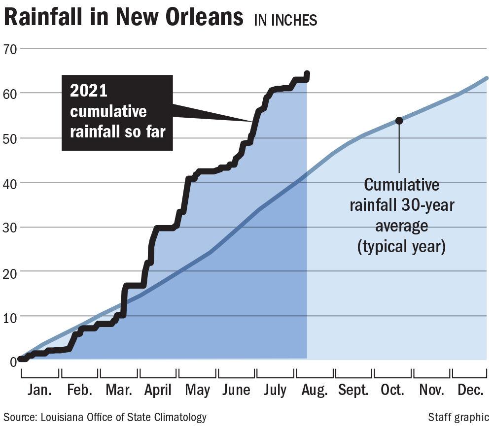
Wet year in New Orleans: Total rainfall measured at Louis Armstrong International Airport for 2021 exceeded the 30-year annual average of 63.35 inches on Friday – with 4½ months left in the year. This year’s total stood at 64.48 on Friday at 4 p.m.
Yes, we live in the tropics but still this is a lot of rain. Part of the problem, as reported earlier, is more intense storms rather than more storms.
Blame Friday’s rain on a deep pool of tropical moisture streaming into the area from the Gulf of Mexico, sandwiched by high pressure systems that are sitting over the western Atlantic Ocean and the western United States, said Christopher Bannan, a meteorologist with the National Weather Service’s Slidell office. “With as much moisture as we have had in place, it does not take much to get storms developing,” he said. Summertime temperatures quickly jumping above 90 degrees, combined with slack winds, created perfect conditions for thunderstorm formation. It’s an unusual pattern that has affected coastal Louisiana for much of the year, with few breaks. “The biggest surprise has really been the pattern we’ve been in, favorable for rain across much of the southeastern U.S.,” Bannan said. “Normally in the summer months, we get those afternoon showers and thunderstorms, and it’s limited. “But this summer, June was an unusually wet month and July was a wet month, and we never got that real strong ridge” of high pressure that would put a brake on thunderstorm formation.
On the bright side, we did have dry spells in between the rain. So the ground could dry out not leaving a soggy mess.
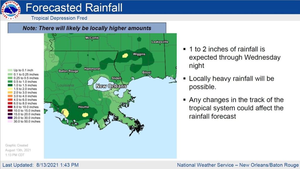
Also lucky for residents this year is that each batch of storms was followed by brief dry periods that allowed soils to dry out, reducing the chance of major flash flooding or rivers and bayous topping their banks. This year’s rainfall total has come in chunks: 2.83 inches between March 22 and 24, 12.84 inches between April 7 and 17, 10.63 inches between May 2 and 12 and 16.79 inches between June 17 and July 17. And don’t expect a break anytime soon. There’s a greater than average chance of increased rainfall over the next few weeks, Bannan said. That’s in part because late August through early October is the most active period of the hurricane season. The season historically peaks on Sept. 10. Slidell forecasters warned Friday that southeast Louisiana is likely to see 1 to 2 inches of rain through Wednesday from the outer edges of tropical depression Fred as it approaches the Florida panhandle.
NATIONAL WEATHER SERVICE ILLUSTRATION
If any organization suffered it was the Sewerage and Water Board. They have been kept busy.
This year’s intense rains, in addition to pushing the total above the annual average, have kept the New Orleans Sewerage & Water Board active. “During an average New Orleans rainfall, our pumping capacity can reach about 51,000 cubic feet per second,” Executive Director Ghassan Korban said. “At such rate, it takes 2.6 seconds to fill an Olympic-size pool. While that sounds like an enormous amount of water, the system has its limitations. Intense rain can overwhelm our designed capacity. “The current system is designed to handle the first 1 inch of rain and a ½ inch every hour thereafter. Any intensity above that, and our system is overwhelmed. When New Orleans experiences a high intensity rain, our responsibility shifts from keeping the city dry to pumping the city [out] as fast as we can.” To reduce the pressure on the New Orleans drainage system, the S&WB has built nine green infrastructure projects, at a cost of $1.2 million, that can hold 300,730 gallons of stormwater. It investing another $2.5 million in 28 similar projects with other local organizations.
What are we to do? Keep the umbrella handy and have shoes that can take the water. This is part of the thrill of living in New Orleans!