
I can say this is no surprise as cancer alley is named that for a reason documented many times.
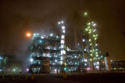
The chemical corridor between Baton Rouge and New Orleans, an 85-mile-long region that environment advocates have long called Cancer Alley, contains several hotspots where cancer risks are far above levels deemed acceptable by the U.S. Environmental Protection Agency, according to a new analysis by the investigative website ProPublica. In fact, it’s the largest hotspot of cancer-causing air in the country, followed by two areas in Texas. ProPublica’s latest findings might come as no surprise to some of the region’s 840,000 residents, after a 2019 collaboration between the nonprofit newsroom and The Times-Picayune | The Advocate showed that the air quality along this stretch of the Mississippi River is steadily worsening as the amount of toxic air pollution in Louisiana’s industrial belt is rising. That analysis also showed that predominantly Black and low-income communities are acutely affected. The new analysis built on the 2019 project, mapping EPA data to quantify cancer risk across the country. It found that more than a quarter million of U.S. residents are exposed to risks considered unacceptable by the EPA. The agency’s standard is that airborne pollution shouldn’t have the potential to cause cancer in more than 1 in 10,000 people who would otherwise would not have developed the illness. The agency isn’t required to penalize companies responsible for pollution that raises cancer risk past this threshold.
nola.com
While this report says nothing new, the ranking as number 1 has raised new awareness.
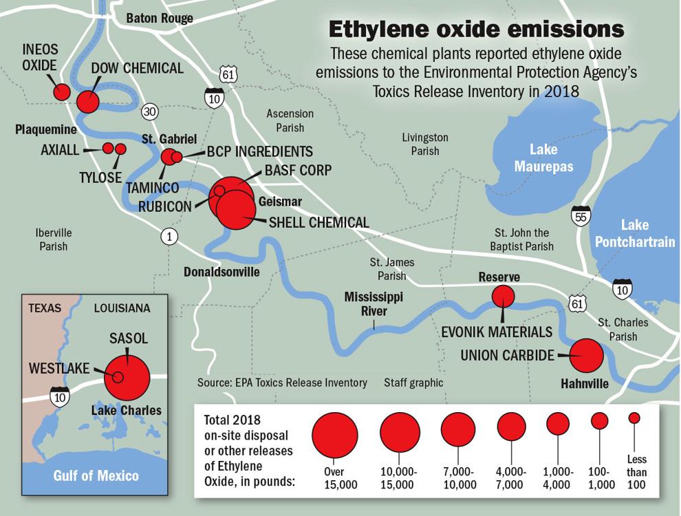
In response to ProPublica’s new findings, Joe Goffman, acting assistant administrator for EPA’s Office of Air and Radiation, said, “Toxic air emissions from industrial facilities are a problem that must be addressed.” Under President Joe Biden’s administration, he said, “the EPA has reinvigorated its commitment to protect public health from toxic air emissions from industrial facilities – especially in communities that have already suffered disproportionately from air pollution and other environmental burdens.” Beyond determining risk at a single point in time, ProPublica’s interactive map lets users see how exposure changed from 2014 to 2018. It also offers a look into how a higher concentration of industrial plants has a cumulative effect on a community’s health. For that, it relies on an EPA tool called Risk-Screening Environmental Indicators, which helps estimate the combined risk from multiple pollution sources in a particular area. Much of that risk is associated with inhaling ethylene oxide, a carcinogen that can cause breast cancer and lymphoma and is manufactured by 13 plants in Louisiana. Those living closest to BCP Ingredients Inc. at St. Gabriel face the highest excess cancer risk in Louisiana due to the chemical: estimated at 1 in 210 people, or 47 times the federal agency’s acceptable risk, due in part to ethylene oxide exposure, according to the analysis. In neighboring Ascension Parish, BASF Corp. and Westlake Vinyls Co. emissions contribute to an elevated risk 26 times the EPA’s standard for those near the Geismar plants. Farther downriver, residents near the Union Carbide Corp. plant at Taft have a risk 32 times the standard.
Ethylene oxide is bad but sadly it is not the only toxic gas.
Ethylene oxide isn’t the only culprit. In Reserve, residents around the Denka Performance Elastomer and DuPont Pontchartrain Works plants experience 32 times the EPA’s acceptable risk due to the presence of another likely carcinogen: chloroprene. Used to make synthetic rubber, the chemical can also increase the risk of liver cancer. The ProPublica map also shows that Louisiana’s pollution problem extends beyond the chemical corridor. Southwest Louisiana holds several hotspots outside of Lake Charles, and with three corporations mostly responsible: Sasol Chemicals LLC, Eagle U.S. 2 LLC and Firestone Polymers LLC. Peak risk there ranges from 4.8 times the level that the EPA considers acceptable to 8.5 times.
As bad as this is, the parishes keep asking for more and the industry keeps trying to put plants there. This is one of the costs that are not figured into the planning as if these are counted, how many plants would be allowed?


