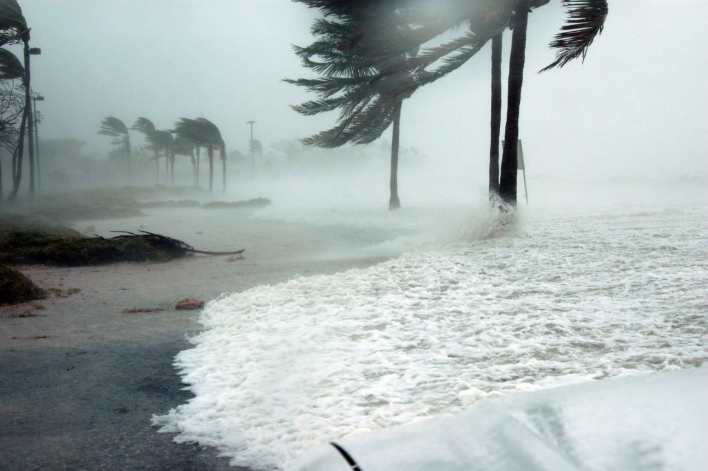
A 1-2 punch, a storm quickly followed by another. Not a good thing as that means no recovery from the first and weaker for the second. But they will be more common.
Louisiana and the west coast of Florida have become more prone to being hit by multiple tropical cyclones as few as 10 days apart, according to a new review of storms hitting the United States coastline since 1979. That new tally should come as no surprise to Louisiana coastal residents. As they mark the last day of the 2021 hurricane season Tuesday, thousands are still cleaning up debris, repairing roofs, and clearing roadways damaged by an array of five landfalling hurricanes in 2020 and three in 2021, including behemoths Laura, Delta and Zeta in 2020 and Ida this year. The tropics generated more than 20 named storms this year. The first, Ana, formed on May 22, even though hurricane season doesn’t officially start until June 1. Elsa, Grace, Henri, Ida, Larry, Nicholas and Sam all strengthened into hurricanes. Last year, forecasters used the Greek alphabet for extra names. It was only the second time in recorded history that Greek names were used. The first time was in 2005, which was the record-setting season responsible for Hurricane Katrina. The new report on the potential for back-to-back tropical cyclones contains still more bad news, though: the chance of sequential storms making landfall in Louisiana could double by the end of the century, if the world does nothing to reduce greenhouse gases, resulting in continued global warming. That’s the conclusion of the new peer-reviewed study by Princeton University climate researchers Dazhi Xi and Ning Lin published in the Nov. 10 online edition of the American Geophysical Union’s Geophysical Research Letters.
nola.com
The data only goes back to 1979 when modern records were started. I can remember on the first ship I was on where we had two weathermen who throughout the day and night launched weather balloons. That was the state of the art in the early 70’s.
Lead author Xi said the review of hurricane records went back only as far as 1979 because that’s when modern satellite tracking of tropical systems began. Records before that relied on local weather reports, reports from ships and planes, and from other observers, meaning some storms likely were missed, or the timing of their growth and landfall was in doubt. According to the study, the limited number of sequential landfalls between 1979 and today makes it difficult to guarantee that the decreasing interval between landfalling storms seen in that period represented the continuation of a pattern from the past. So the team used estimates developed through forward-looking runs of climate models to confirm that the number of sequential storm events will increase in the future, based on that historical pattern and an understanding of the increasing effects of global warming on tropical systems: an increase in the number of storms making landfall in the U.S., a lengthening hurricane season, and more storms stalling just as they come ashore.
Noting the number of storms is easy, harder is finding the cause.
There remains a debate in the scientific community about whether the total number of hurricanes that have occurred each year were in the past mostly affected by a natural phenomenon called the Atlantic Multidecadal Oscillation. The AMO has been believed to be a pattern of 40-60 years of cooler sea surface temperatures in the northern Atlantic Ocean caused by slowly changing currents and salinity levels, followed by a similar period of warmer sea surface temperatures. The warmer temperatures allow more tropical systems to form. The most recent warm AMO trend began in 1995 and is believed to still be a dominant factor in tropical system creation. But Xi said future sea surface temperatures will be mostly controlled by the continued human-related global warming. And, he said, if the oscillation does return to a cooler period, he doesn’t expect it to have much effect on the speed-up of sequential landfalls.
In Louisiana we know back to back storms. We have had them, just ask Lake Charles.
Louisiana was actually hit by three storms in rapid succession in 2020: the remains of Tropical Storm Beta on Sept. 20, which caused $225 million in damage; Category 2 Hurricane Delta on Oct. 9, which had a price tag of $2.9 billion; and the Category 3 landfall of Hurricane Zeta on Oct. 24, $3.9 billion. The damage estimates quoted in the study were reported by the Aon Benfield reinsurance company. Recognizing the threat of back-to-back storms to both the public and the environment is important for disaster planning, the study said. Sequential tropical cyclones “are hazardous if the landfall interval is shorter than the time scale of recovery of coastal communities and ecosystems,” the paper said. For the public, that’s because it may take more than two weeks to restore basic services, including electricity and other utilities and transportation. The report pointed out that in the aftermath of Hurricane Ike in 2008, it took as long as 17 days to restore electricity to much of the Houston area. After Hurricane Sandy in 2012, it took two weeks to restore the New York City subway system to a 95% level of service. And as much of southern Louisiana was reminded during the active hurricane seasons of 2020 and 2021, it can take much longer to restore damaged and weakened buildings and to pick up debris.
It is also the coastline that suffers from back to back storms.
The threat to Louisiana’s coastline by such back-to-back storms was raised during a recent Coastal Protection and Restoration Authority meeting by authority board member Laurie Cormier, the coastal zone administrator for Calcasieu Parish. “In the southwest Chenier Plain area, we keep getting hit by back-to-back storms. Last year we were hit by five or six storms and there is potential to do that in the future,” Cormier said during an update of the modeling being used to select restoration and levee projects for the upcoming 2023 update of the coastal Master Plan. “Do we start with a landscape that’s already been hit by a storm and then has another storm that comes right behind it?” she asked. Existing models are not yet able to deal with such a scenario, said Stuart Brown, who oversees the plan. “It’s just an area where the tool is not fine-scale enough to capture additional stresses,” Brown said.
To survive we need resilience, and our SWB is a good example were it does not exist.
In their study, Xi and Lin point out that past studies have made clear that the resilience of existing utility and transportation systems must be increased to withstand the effects of tropical landfalls. The new study, they said, reinforces that point, but also indicates a need to plan in advance to deal with the after effects of multiple storms. In Louisiana, their study found that by the end of the century, the return period for two storms hitting within 20 days of each other would decrease from once every 35 years to once every four years. In Texas, the present 17-day interval between storms is now a 40-year event, but would drop to below 10 years in the future. According to the study, Louisiana’s chances of sequential landfall are greater than Texas, and the chances increase along the Mississippi and Alabama coastlines, increasing again on the Florida Panhandle and along the Florida west coast.
Another aspect of climate change and one that puts us in a greater risk.


