
State and federal trustees have approved spending $21.2 million to restore marsh habitat and rebuild a ridge along Bayou La Loutre on the west side of the Mississippi River-Gulf Outlet, in the area marked on this satellite photo.
(Photo courtesy of Google Earth)
The BP oil spill money continues to provide the State to help stem flooding.
A popular fishing area along the Mississippi River-Gulf Outlet and the rapidly disappearing Raccoon Island are among the state’s latest coastal restoration efforts being paid for by BP oil spill money. State and federal trustees overseeing the restoration of natural resources damaged by the 2010 BP Deepwater Horizon oil spill have approved spending nearly $75 million on two projects in the New Orleans area and another two in Terrebonne Parish. They have also begun a public review of a plan to spend $34 million to rebuild a Terrebonne Parish island as a bird habitat. Several of the projects also will provide additional protection to populated areas from storm surge. The Louisiana Trustee Implementation Group oversees the spending of about $5 billion set aside to restore the effects of the spill. It is part of a $20.8 billion civil settlement between the five Gulf states, the federal government and BP in 2016. The Louisiana trustee group includes a range of state and federal officials. There was a separate multi-billion-dollar criminal settlement between BP, its drilling partners and governments.
nola.com

(Louisiana Trustee Implementation Group)
The New Orleans area benefits as well.
In the New Orleans area, the trustees have approved spending $21.2 million for construction costs to restore about 5 ½ miles of ridge habitat along Bayou La Loutre on the east side of the Mississippi River-Gulf Outlet, and to create and nourish about 421 acres of marsh between that part of the bayou and Lena Lagoon to its north. “The project would restore much of the Bayou La Loutre ridge, including live oak/hackberry maritime forest, which would provide valuable habitat to migratory birds,” said the final restoration plan and environmental assessment for the four projects. “The project would also create marsh in these areas, which would serve to stabilize the project area with a healthy vegetative marsh environment and provide a buffer to the ridge against highly erosional winter storm events.” The work is north of the dam built in 2009 across the MR-GO to permanently block saltwater from moving north, after Congress deauthorized the failed 76-mile shipping shortcut to the Industrial Canal in New Orleans after Hurricane Katrina. Planned to help New Orleans compete with Houston as a major port in the 1940s, the canal was completed in 1968 with a depth of only 36 feet. It fast became obsolete, as ocean-going vessels grew in size to match the deeper Panama Canal. Earlier this month, federal and state officials celebrated the completion of deepening the Mississippi River from its mouth to New Orleans to 50 feet to accommodate those larger ships. Dredging of the MR-GO cut through the natural ridge that runs along the southern side of Bayou La Loutre. Ship and boat traffic, along with the saltwater the shipping channel allowed into the area, eroded the marsh in the area. While the shipping channel was authorized to be 500 feet wide, it eroded to as much as 2,000 feet across in some locations.
Who pays and how much has stalled the project so far.
A $3 billion Army Corps of Engineers plan to restore wetlands eroded by the MR-GO has been stalled since 2009 because the Corps insisted the state pay 35% of its cost. Pending U.S. House and Senate bills call for that project to be either fully paid for by the federal government or for the state to only pay 10%. When that plan was delayed, however, federal and state officials moved forward with work for several projects it contained, using other funding sources. If the feds end up footing the bill for MR-GO restoration, CPRA executive director Bren Haase said the state would seek either reimbursement or credit. The bayou — located in an area well-known to local anglers — will be dredged to 10 feet deep. The dredged material will be used to raise the ridge on its southern bank from its existing height of about 1.8 feet above sea level to between 5 and 6 feet, with a 15-foot-wide crest. Sediment will be dredged from Lake Borgne to create about 163 acres of new marsh and to nourish about 258 acres of existing marsh along Lena Lagoon. Officials expect construction to take about 15 months.
(Photo courtesy of Google Earth)
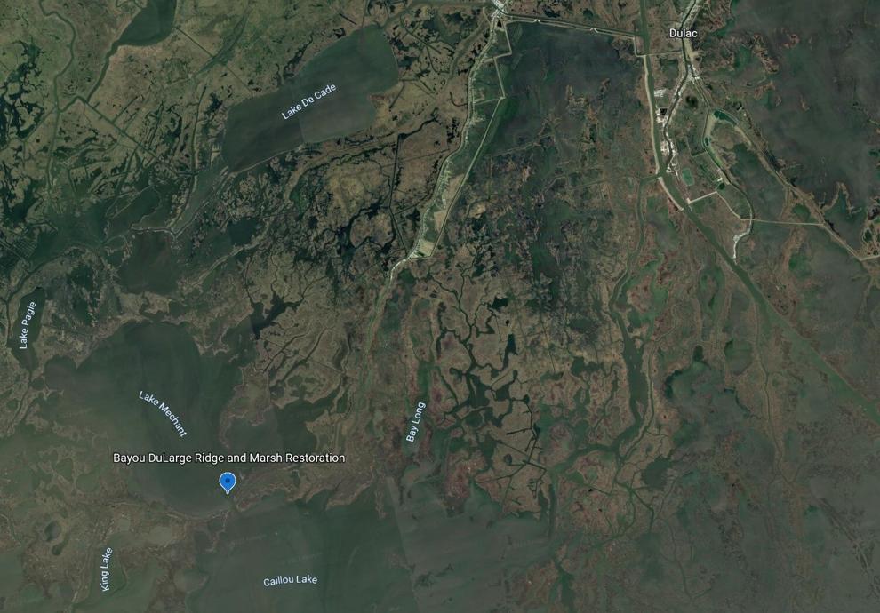
Also a ridge and marsh will be built.
The second construction project calls for the creation of ridge and marsh habitat along a 5-mile segment of Bayou Dularge in the central Terrebonne Basin marshes, at a cost of $41.4 million. The project is located on what geographers call a “land bridge” made up of eroding ridge and wetlands south and west of Dulac and Cocodrie in Terrebonne Parish. It will take another 18 months for final design work, permitting and bidding, and then 16 months to complete construction. According to the report, all of the project’s features are being built to last at least 25 years. The ridge and marsh creation and nourishment work will be built on the southern side of the bayou just south of Mud Lake and Lake Mechant, and north of Caillou Lake. Marsh in that area, the remains of one of the Mississippi River’s past deltas, has been disappearing as a result of insufficient supplies of both freshwater and sediment, accelerated sinking of the land due to oil and gas exploration, saltwater intrusion and boat traffic in the bayou and in nearby passes. “The loss of land area over time within the Terrebonne Basin in general, and the Bayou Dularge Ridge specifically, has increased the vulnerability of landward coastal communities to storm surge,” the restoration plan said.

(Louisiana Trustee Implementation Group)
Building the ridge helps more than just the flood protection. Marshes are integral to the Delta area.
Restoring ridge habitat — making the land along the bayou high enough to support live oak and hackberry trees — will also assist migratory bird species. As much as 500 acres of new marsh would be created in open water areas. Dredged material would be used to elevate marsh areas to about 1.3 feet above sea level, high enough to be used as a marsh grass platform for at least 20 years.

(Photo courtesy of Google Earth)
The East New Orleans land bridge will also be part of the work.
The trustees also approved spending $4 million on final engineering and design work for restoration of part of the East Orleans Landbridge, a segment of rapidly eroding marsh that separates Lake Pontchartrain from Lake Borgne, and is south of the stretch of U.S. 90 leading to Slidell. The engineering and design work is estimated to take three years to complete. After that, the trustees will make a final decision on moving forward to construction. If built, the project is expected to create or restore about 1,563 acres of emergent brackish marsh just east of the Rigolets. According to Louisiana’s 2017 coastal Master Plan, about 32% of the remaining wetlands outside the levee system in easternmost New Orleans are expected to be lost over the next 50 years. “Without healthy and dense marshes on the landbridge, the hurricane levees are at an increased risk for overtopping or breaching,” the environmental assessment says. “Even if these worst-case scenarios do not happen, the lack of an effective landbridge would cause more wear and tear on the city’s levee system, causing an increased burden on residents to finance maintenance of the system.”

(Louisiana Trustee Implementation Group)
Wetlands provide so much.
The wetlands also provide some protection to the Venetian Isles and Lake Catherine neighborhoods, which include a number of homes elevated to 20 or more feet above ground level because of the risk of hurricane storm surge damage. The state CPRA began construction in June on a separate $25 million project restoring 253 acres of the East Orleans Landbridge wetlands near the proposed new project. Trustees also approved spending $8.2 million to complete engineering and design work to again rebuild Raccoon Island, the westernmost of the Isles Dernieres barrier islands, on the southern edge of Caillou Bay in Terrebonne Parish. According to the report, the island is the home to one of 10 remaining brown pelican colonies in the state.
(Coastal Protection and Restoration Authority)
Racoon Island has lost much of the land from what it used to be.
The 81-acre island is losing sediment and has seen its shoreline recede even after three earlier attempts to increase its size and protect its southern edge with rock breakwaters, dating back to 1994. The island is the westernmost remaining portion of what was once known as Last Island, or Isle Derniere, a miles-long barrier island first cut up by a Category 4 hurricane in 1856. “All of Raccoon Island is forecasted to disappear by 2050 without further restoration actions,” the report said. “It is one of the most productive avian nesting areas in the northern Gulf of Mexico, providing nesting habitat for multiple species of colonial waterbirds and ground nesters.”

(Louisiana Trustee Implementation Group)
The Houma area also gets some of the money.
The trustees have also announced a plan to spend $34 million to rebuild and expand a tiny island in the Houma Navigation Canal in Terrebonne Parish to benefit bird species injured by the oil spill. The project would add 14 acres to the 27.6-acre island, and build about a mile of rock dike around its perimeter.

(Photo courtesy of Google Earth)
The Corps is looking for comments.
Comments on the draft plan for this island project can be made online, at https://parkplanning.nps.gov/LATIG71, by mail to U.S. Fish and Wildlife Service Gulf Restoration Office, 1875 Century Blvd., Atlanta, GA 30345, or during a public webinar at 2 p.m. Sept. 8, which will be followed by the trustee group’s annual public meeting. Registration for both webinars is available online: https://attendee.gotowebinar.com/register/1617789947761424400.

(Louisiana Trustee Implementation Group)
The BP spill was bad and caused a lot of damage but what the State has gotten from the settlement has done more good.


