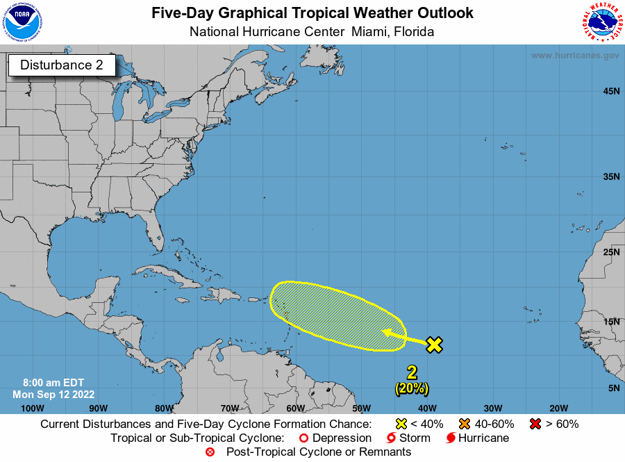
I thought they did weekend updates but I guess not. So we lost 2 but kept 2 and one does look like it will be in the Caribbean. This is for Monday the 12th of September.
Hurricane forecasters on Monday were tracking two disturbances in the Atlantic.
Hurricane forecasters on Monday were tracking two disturbances in the Atlantic. It’s too early to say where they could go if they develop. The next available name is Fiona, if either strengthens into a tropical storm. The Caribbean Sea and the Gulf of Mexico are expected to stay quiet for the next 48 hours, forecasters said. The shaded area on the graphic is where a storm could develop and is not a track. The National Hurricane Center releases a track when a tropical depression forms or is about to form. The categories, in order of increasing strength, are tropical depression, tropical storm and hurricane (categories 1 through 5). Here’s what to know about the tropics as of 7 a.m. Monday from the National Hurricane Center.
nola.com

Slow development possible.
Hurricane forecasters are tracking a tropical wave that’s midway between the west coast of Africa and the Windward Islands. It’s producing a large area of disorganized showers and thunderstorms. Some slow development of this system is possible over the next several days, forecasters said, as it moves west. It’s expected to approach the Windward Islands by the end of the week. The system has a 20% chance of developing into at least a tropical depression within five days.

Disturbance off coast of Africa.
Forecasters are tracking a tropical wave off the west coast of Africa that is moving west to north west. It has disorganized showers and thunderstorms, and forecasters said environmental conditions are only marginally favorable for further development. It has a 20% chance of developing into a tropical depression within five days.
As I have done before, I will stop here as the rest has been posted before. The one heading the Windward Islands is the one I will keep my eye on!


