A drought up and done the Mississippi has put the water level at dangerous lows.
Old Man River is shriveling. Barges are running aground. The nation’s shipping industry is concerned. But you wouldn’t know it from Tony DeMarco’s deck overlooking the not-so-mighty Mississippi. He lives on the river side of the levee on the parish line between Orleans and Jefferson – only a short walk from the city’s bustle, but seemingly a world away. The water is much lower than usual from his vantage point, exposing sand and driftwood along its banks, but life continues at its own pace. “Peaceful,” said DeMarco, 72, whose house is among a dozen along the strip of land known as the batture between the levee and the river. “Nothing but rabbits, possum, squirrels.” Others throughout the country concerned with the river can’t afford to be so sanguine. Recent weeks have been a reminder of how much the nation depends on rainfall and where it drains.
nola.com
Technology does not help to stem a lowering river.
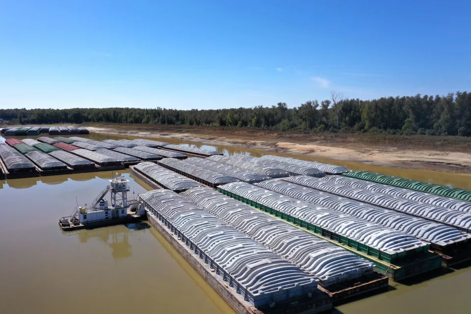
Despite all of the technological advances of recent decades, an extremely low Mississippi River can still wreak havoc. It has threatened the supply chain and drinking water supplies. Emergency dredging operations have been deployed and an underwater levee is being built. Because of persistent drought around much of the country, the situation may not significantly ease anytime soon for the waterway that drains 41% of the contiguous United States and carries 60% of the country’s grain exports. Many are watching nervously. “At this point, it’s acts of God that you’re waiting on,” said Micah Cormier, spokesman for the Port of South Louisiana, whose facilities upriver from New Orleans handle 100 million tons of grain destined for 90 countries annually. “The eyes of the world are on America right now.” Local ports haven’t seen any drastic impact yet, officials say, though barge availability and the amount of goods vessels can carry have been affected. A number of cruises along the river have also been halted.
It is worse up river as the drought has cut the flow into the river.
But further north, the situation is more dramatic. The river at Cairo, Illinois, at the Mississippi’s confluence with the Ohio, was approaching its lowest level since 1901, the Tennessee Valley Authority said last week, prompting plans to release water from two dams. Dramatic pictures from the Memphis area and elsewhere show the river shockingly dry. In Missouri, sightseers were walking on dry land normally covered by the Mississippi to reach the island landmark known as Tower Rock. Closer to home, the water level dropped low enough in Baton Rouge to reveal a century-old shipwreck. In the New Orleans area, the Harvey Lock has been shut because of low water, though vessels can still maneuver their way to the nearby Algiers Lock, which remains open. The Coast Guard reports at least 30 vessel groundings, while the Army Corps of Engineers says it has deployed five dredging operations around Memphis and St. Louis. The river may have to be closed in sections for further emergency dredging, the Coast Guard warns.
We don’t see much of the drop here until you look at the gauges.
The effects are less apparent here because the river is far deeper in south Louisiana, both due to naturally occurring reasons and dredging. But the sight is still unusual. At the Fly in Audubon Park, Doug Nichols scurried down the rocky banks toward the water with the help of a walking stick. The low river exposed a sandbar, and the dank smell of the wet ground wafted on the breeze. “I’ve been reading lots of reports about it, so I’m curious,” said Nichols, a lawyer. The river stages in part tell the story. At the Carrollton gauge in New Orleans, it was 2.2 feet at noon on Friday and forecast to drop further. The record low dates to 1.6 feet in 1872, though comparisons are difficult outside of the modern era given the vast changes in the river’s course. That does not mean the river is 2.2 feet deep at Carrollton. The stage is relative to Gulf sea level; the actual depth of the river in the New Orleans area is far greater, dropping to as much as 190 feet at Algiers, said Corps sFurther north, Memphis set a modern-day record low last week, according to preliminary readings. Spokesman Ricky Boyett. The Corps goes into a “flood fight” when the river gets up to 11 feet above sea level at Carrollton, though levees protect the city to more than 20 feet. To put it into further perspective, the Bonnet Carre spillway is opened when the river’s flow reaches 1.25 million cubic feet per second at the Carrollton gauge. On Friday, the flow there was about 160,000 cfs, or around 13 percent of the trigger.
The cause is obvious as is the solution. No rain means we need rain.
The reason it’s so low is simple: no rain. Wide swathes of the country are in a drought, starving the river of the runoff that usually flows within its banks. Jeff Graschel of the National Weather Service said levels on the river’s lower end are lower than they’ve been since 2012, while further north they’ve approached 1988 levels. Both were years with lengthy periods of drought. It could be weeks before levels begin to return to some degree of normal, he said. This time of year often means lower river levels, with depths returning as the weather shifts throughout November, he said. “There’s not any long-range models that are giving us any occasions for rainfall that’ll generate runoff to help and alleviate low-water conditions right now,” he said. “Obviously everybody’s watching that very closely.” He explained that the rain would need to occur in the upper section of the river valley, such as Illinois, for the effects to be felt further south. Rain that falls in south Louisiana does not drain through the Mississippi, save for what lands directly in the river.
We get our drinking water from the river so that is a concern.
One important area of concern for south Louisiana involves drinking water. The New Orleans area uses the river as its source, but when the Mississippi is this low, saltwater moves upstream from the Gulf. Municipal or parish treatment systems aren’t equipped to desalinate water, prompting the Corps to take action to break up the “wedge” of saltwater invading the river. It deals with it by building a sill made of sediment – essentially an underwater levee – that interrupts the path of the saltwater, which is at the river bottom because it’s denser, and stops its advance. The Corps carried out similar work in 1988, 1999 and 2012. Boyett said construction of the sill along the riverbed near Myrtle Grove was expected to be complete on Friday at 35 feet. Areas below the sill in Plaquemines Parish have had to take further precautions. Two machines were being brought in to filter the salt from drinking water. The first two were diverted because of needs related to Hurricane Ian in Florida, but one has since arrived in Plaquemines and was being set up, said Parish President Kirk Lepine. The second was on the way. An advisory for areas from the Empire Bridge to Venice has been in effect for those on dialysis or low-sodium diets.
For others this is just a chance to see the river in this stage.
But while others are concerned, DeMarco is going with the flow from his house on the batture, where he’s lived for around 35 years. The camp-style houses located there have been grandfathered in from an earlier era, providing residents like DeMarco a rare front-row view of the river’s rise and fall. He’s never flooded, though the water has come within a couple feet of his house when the river was especially high. It’s certainly nowhere near it now. “After living here, I couldn’t live over there with the neighbors next to me,” said DeMarco, who makes his living from real estate, taking in the view of the river’s bend.
We see no rain and think of trees and flowers. They are all linked by the lack of rain.


