Diversion (MR-03), is shown above.
https://www.lacoast.gov/reports/gpfs/MR-14.pdf
The Coastal Plan is spending money for surge protection that will save costs in damages not happening.
Louisiana’s draft 2023 coastal plan calls for spending $50 billion over the next half century to build a slew of coastal restoration and flood protection projects and reduce annual storm surge damage by as much as $15 billion. The state would save an average of $11,000 in damages per structure by 2073 under the plan’s lower risk scenario and $15,000 in damages per structure under its higher risk scenario. Half of the plan’s money would be spent in the next 20 years on projects that are immediately needed and are most likely to be funded. The second half of its money would be spent in the following 30 years on projects that still need to be planned or funded, or that would only be enacted if water levels rise further.
nola.com

This is the plan and the categories used.
The restoration funding, divided among seven categories, includes: $230 million for projects aimed at bettering the flow of water into and through wetlands; $2.5 billion for projects that include barrier island maintenance and repair and local strategies, like bank stabilization and oyster reef restoration;

Continuing
$37 million for projects aimed at creating speed bumps of slightly higher land within marsh and wetland areas to reduce erosion and slow storm surges; $16 billion for marsh creation projects;

And more
$2.9 billion for projects aimed at building or restoring wider land stretches using sediment dredged from rivers and bays, and aimed at restoring or creating higher ground that would support adjacent wetlands, include wetlands themselves, and reduce storm surge height; $2.7 billion for both freshwater and sediment diversions; $640 million for integrated projects, which combine features from multiple project types into one integrated concept.
Flood risk is als one of the categories
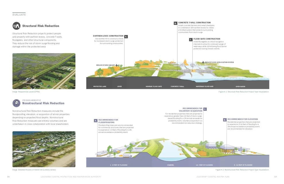
The flood risk reduction funds include two categories: $14 billion for structural risk reduction projects, including levees, floodwalls and gates. And $11 billion for so-called “nonstructural risk reduction,” combinations of elevating homes above expected future base flood elevation levels or buyouts in flood zones, and floodproofing of commercial structures.
There are nonstructural projects that do not have a category.
The nonstructural projects do not show up as individual projects in the master plan, as they often are identified on a building-by-building basis on a local scale and are funded through programs in which the Coastal Protection and Restoration Authority is not involved. An exception has been the Southwest Coastal Louisiana project, funded by the U.S. Army Corps of Engineers. The project is being funded with $296 million to address elevation, floodproofing or possible relocation for more than 3,900 structures in the Lake Charles region. The Corps also expects to fund elevations or floodproofing of about 8,500 structures in St. Tammany Parish. Other nonstructural projects are expected to be overseen by the state Office of Community Development or the Governor’s Office of Homeland Security and Preparedness, since funding for them often is given to the state after natural disasters, including hurricanes and major flood events.
The regions of the states projects. Pontchartrian/Breton
This region includes areas on the east bank of the Mississippi River from Ascension Parish through Plaquemines Parish, including the New Orleans area and the north shore, including Slidell. The plan calls for construction of 18 restoration projects and four levee and surge barrier projects that will cost $11.6 billion. Lake Pontchartrain Barrier in New Orleans and Slidell, $2.4 billion, will include closure gates and weirs built to an elevation of 2 feet above sea level across the passes at Chef Menteur and the Rigolets to reduce hurricane surge heights affecting south shore and north shore communities along the lake. Slidell ring levees, $420 million, included in a broader Army Corps of Engineers plan for north shore flood risk reduction, includes a 16.5-mile combination of earthen levee, concrete T-wall, and four gates around the city built to heights of between 13 and 17 feet. Braithwaite to White Ditch hurricane levee in Plaquemines Parish, $440 million, to elevate the non-federal levee to about 15 feet above sea level, which could provide protection from 100-year surges to communities behind it. St. James-Ascension Parishes Storm Surge Protection, $730 million, in the second implementation phase that begins in 2044. An upriver extension of the West Shore Lake Pontchartrain levee system, this project includes about 28 miles of earthen levee and concrete T-wall built to 16 feet, gates and culverts, and four pump stations, to provide protection from hurricane surge flooding from Lakes Maurepas and Pontchartrain. Upper Basin Diversion Program – Pontchartrain, $760 million. The projet calls for a number of diversions to deliver freshwater and sediment into swamps of the western Pontchartrain basin. Diversions will be evaluated to see how they can be operated in conjunction with other planned and completed diversions to maintain swamps, and coastal marshes and to help with Mississippi River flood control, with the studies determining whether one or more diversions will be added in the basin. New Orleans East Marsh Creation, $1.1 billion, in second implementation period, would create new marsh in a 45 square mile area adjacent to the New Orleans East Landbridge Marsh Creation project. Pointe a la Hache and Carlisle Marsh creation, $860 million, create new marsh along the east side of the Mississippi River from White Ditch to Bohemia. North and East Lake Lery Marsh Creation Project, $890 million, in second implementation period, woulld create about 22 square miles of new wetland habitat, restore degraded marsh and reduce wave erosion.

(CPRA Master Plan data viewer image)

Barataria
The Barataria region stretches between the west bank of the Mississippi and the east bank of Bayou Lafourche, and includes parts of nine parishes, Assumption, Ascension, St. James, Lafourche, St. John the Baptist, St. Charles, Jefferson, Plaquemines and Orleans. The plan calls for 10 restoration and two levee projects, totaling $6.7 billion. Here are a few: Lafitte Ring Levee, $1.4 billion, in implementation phase 2. The present system, 7.5-feet high, would be expanded to include more than 28 miles of levees and floodwalls elevated to 16 feet. The project would include two barge gates and a roller gate, Upper Barataria Risk Reduction levee system, $510 million. This recently authorized system expands levees in the west bank of St. Charles Parish to extend along U.S. 90 to Raceland. It includes more than 38 miles of earthen levees and concrete T-walls, a barge gate, two roller gates, six sluice gates, and pump station improvements, East Bayou Lafourche Marsh Creation, $1.3 billion, includes creation of marsh within a 52-square-mile area east of Bayou Lafourche and along the Caminada headland at the Gulf Coast, Lower Barataria Landbridge-East, $840 million, in the second implementation period. Includes creating about 11 square miles of marsh, much in areas deeper than 2.5 feet, from Bayou Dogris to Port Sulphur. The project also includes about 25 miles of shorelie revetments to reduce erosion, and channel armoring to maintain current dimensions in the Wilkinson Canal, Wilkison Bayou, Bay Chene Fleur, in channels north of Bay Batist, Two Sisters Bayou, Scocia Canal and Grand Bayou, and Upper Basin Diversion Program – Barataria, $750 million. A sister to the similar Pontchartrain program, the projet calls for a number of diversions to deliver freshwater and sediment into swamps of the upper Barataria Basin. Diversions will be evaluated to see how they can be operated in conjunction with other planned and completed diversions to maintain swamps, and coastal marshes and to help with Mississippi River flood control, with the studies determining whether one or more diversions will be added in the basin.

Terrebonne
The Terrebonne region extends from the Verret Basin in the north to the Isles Dernieres and Timbalier Islands along the Gulf, and from the west side of Bayou Lafourche to the Atchafalaya Basin Floodway. The plan calls for 13 restoration and three levee projects totaling $11.3 billion. Here are some of them: Morganza to the Gulf, $3.9 billion, to complete about 90 miles of the hurricane levee system that protects the Houma region, Amelia Levee Improvements, $840 million, in second implementation period beginning in 2044, would elevate about 5 1/2 miles of levee and T-wall, with the levee built to about 18 feet, The project includes several barge gates, swing gates and other gates. Larose to Golden Meadow, $500 million, in second implementation period, to keep this 50-mile levee and floodwall system elevated to a 100-year protection level, requiring levees to be elevated to between 12 and 21 feet, West Terrebonne Marsh Creation Project, $1.5 billion, creating new marsh in a 34-square-mile area between Caillou Lake and Caillou Bay, Belle Pass-Golden Meadow Marsh Creation, $1.2 billion, creating new marsh in a 45-square-mile area from Belle Pass to Golden Meadow and Eastern Terrebonne Landbridge – West and Central project, $1 billion, includes filling areas deeper than 2.5 feet to create marsh stretching from Bayou Pointe-aux-Chênes to the south LafourcheLevee near Catfish Lake. Project includes adding nearly 6 miles of shoreline revetment and channel armoring, and restoring more than 8 miles of the Bayou Pointe-aux-Chênes ridge.

Central Coast
This region includes shallow coastal bays between the Atchafalaya Floodway levee and Fourleague Bay to the east, and Freshwater Bayou to the west and stretches inland to the lower reaches of the Atchafalaya Floodway. Iberia/St. Mary Upland Levee, $1.7 billion. This project, which will reduce flood damage in New Iberia, Jeanrette and the Port of New Iberia, includes just over 31 miles of earthen levee and concrete T-wall that will be built to elevations of between 15.5 and 20 feet in the two parishes between the Delcambre and Cherenton canals. It also includes seven pump stations and a variety of gates. Abbeville and Vicinity hurricane levee, $610 million, in second implementation phase beginning in 2044. Includes just over 19 miles of levee and T-wall south of Delcambre, Erath and Abbeville, roughly following La. 330. Franklin and Vicinity, $310 million, in second implementation phase, includes improvements of 40 miles of earthen levee from the Wax Lake Outlet to the Charenton Canal, and will improve flood protection for the town of Franklin and surrounding communities. Marsh Island Barrier Marsh Creation, $710 million, to create marsh in an 8,200 acre area on Point Au Fer Island.

Chenier Plain
This southwest Louisiana region includes parts of Calcasieu, Cameron, Jefferson Davis and Vermilion parishes, and includes the Calcasieu Ship Channel and Lake Charles. East Pecan Island Marsh Creation, $650 million, will create new marsh in a 19-square-mile area between Pecan Island and the Freshwater Bayou Canal in Vermilion Parish. West Sabine Refuge Marsh Creation, $640 million in the second implementation period, and West Sabine Refuge Marsh Creation – Central, $130 million, in the first period. These projects will create new marsh in east of Sabine Lake in Cameron Parish to create new habitat and reduce wave erosion.
A master plan data viewer also is available online. A PDF version of the plan is available below: https://www.nola.com/draft-louisiana-2023-coastal-master-plan/pdf_394a623a-8e17-11ed-8466-5739c766cf69.html
A lot of work. A lot of money. All needed to keep us here.