
The BP spill has given us money for coastal restoration but what about the wildlife?
Is the more than $8 billion being spent on restoring damage caused by the 2010 BP Deepwater Horizon oil spill succeeding in rebuilding wetlands, restoring coastal bird and sea turtle nests, and improving conditions for fisheries? Federal and state trustees overseeing the money in Louisiana recently announced that they’ve set aside $36.5 million to answer that question, including making recommendations for adapting non-performing projects, over the next six years. The Louisiana Trustee Implementation Group, including representatives of the state Coastal Protection and Restoration Authority and a variety of federal agencies, worked for more than a year with a team led by scientists with the Baton Rouge-based The Water Institute of the Gulf to fine-tune the monitoring of restoration efforts that began soon after the spill. Last year, the group published a strategy to identify the seven new monitoring programs. The restoration efforts themselves are based on goals outlined by federal and Gulf state agencies in a 1,569-page damage assessment and restoration plan released in 2016.
nola.com
(Graphic by Kate Sweeney for NOAA)
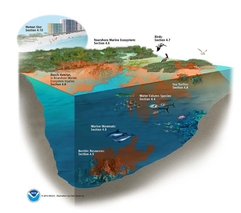
These are the areas of study which include
Coastwide Louisiana Colonial Waterbirds
Researchers will conduct aerial photographic surveys of colonial waterbird nests along the Louisiana coast, following up on similar surveys of nests done through 2013 after the spill. The survey will focus on shrub-nesting birds, many of which nest on barrier islands and shorelines, including brown pelicans, reddish egrets; little blue, tricolored, black-crowned and great blue herons; and roseate spoonbills. It also will identify ground-nesting birds, including royal, sandwich, Caspian, gull-billed, and Forster’s terns; black skimmers and laughing gulls. The surveys will include high-resolution imagery in 2024, 2026 and 2028 of nest locations on both unrestored islands and on islands and other rookeries restored with BP natural resource restoration funds. The locations of nests and individual birds and chicks will be marked and electronically counted. For some species, like brown pelicans, nests will be ranked by their stage of development. The $5.8 million for this project includes upgrading previously collected data to current monitoring standards.

(Louisiana Trustee Implementation Group)
Documenting Sea Turtle Nesting in Louisiana
This $2.7 million survey’s aim is to better identify what sea turtles nest on Louisiana beaches, where the nests are located, and what steps might be taken to allow more hatchlings to survive. “Few attempts have been made over the past decades to conduct such surveys despite sporadic, mostly anecdotal evidence of nesting,” according to the monitoring plan. The most recent evidence of sea turtles in Louisiana includes:
- Two confirmed loggerhead nests at Grand Isle State Park in June and July 2015, with low hatch success. Only 55 of 112 eggs hatched in one nest, and only 20 of 110 eggs hatched in the other.
- Three loggerhead crawl paths were documented by the U.S. Geological Survey in July 2015 from aerial surveys of the Chandeleur Islands.
- One confirmed Kemp’s ridley turtle was recorded actively nesting on the Chandeleur islands in 2018, reported by a fisherman.
- And state officials spotted 53 crawl paths, evidence of baby turtles dragging themselves from nest to water, believed to be made by Kemp’s ridley and loggerhead turtles, and five verified hatch nests, during 10 aerial survey days and a trip to the Chandeleur Islands between May and August 2022.
The plan is to compile and evaluate available data on nesting areas and the characteristics of the beaches on which they’re located, and to conduct new surveys that will capture evidence of sea turtle crawls and nests.A census of sea turtle nesting will be conducted in the second and third year of this survey, using aerial surveys by planes or drones and documenting potential threats to nesting beaches on foot. Assessment of nests will be conducted at least three days after hatching to document the number of hatched and unhatched eggs, and collecting the nest contents for genetic analysis to document species. The nest surveys will be conducted between March 1 and August 31, depending on funding, weather and access to aerial equipment. The ultimate goal will be to provide baseline data on nesting and suitable beaches in Louisiana that can be compared to others across the northern Gulf.

(Louisiana Trustee Implementation Group)
Louisiana Fisheries Independent Monitoring Program
The $4 million provided by the trustees will be added to existing funding from the state and federal agencies to support the state’s collection of fisheries data. The data also will be used to assess population dynamics for estuarine-dependent species injured during the spill, and to assess the impacts of restoration projects paid for by all BP spill-related funds on fisheries. Among the species injured during the spill that will be monitored are southern flounder, red drum, gulf killifish, brown and white shrimp, fiddler crabs, eastern oysters, Gulf sturgeon, red snapper, and spotted seatrout. Fishery sampling will be conducted in various locations using various sized trawls and seines.

(Louisiana Trustee Implementation Group)
Lower Food Web Sampling in Barataria Estuary
Researchers will sample the “lower trophic level” of organisms – the bottom of the food chain – in the Barataria estuary, where much of the restoration is being conducted, including the upcoming $2.92 billion Mid-Barataria Sediment Diversion. The $7.6 million sampling program will target microscopic plants called phytoplankton, cyanobacteria and microalgae living on water bottoms called microphytopenthos, tiny animals called zooplankton, and sediment-dwelling organisms known as macroinfauna. All are sources of food for differing types of fisheries. The sampling will in part be aimed at tracking changes in species as projects are built and, in the case of the diversion, operated. When the diversion is operated, it will increase the amount of freshwater and sediment within the basin, and that’s expected to result in major changes in the types of organisms living in various locations over time.

(Louisiana Trustee Implementation Group)
Louisiana Coastwide Reference Monitoring System
Primarily funded by the federal Coastal Wetlands Planning, Protection and Restoration Act, the system includes about 400 monitoring stations across the coast. That information has been key to the state in identifying land loss and gain trends. The federal-state task force overseeing CWPPRA has been trying to identify alternative funding sources for the complex system, and this grant would pay $11.1 million, or about 22%, of the system’s costs from fiscal year 2024 through fiscal year 2027.

(Louisiana Trustee Implementation Group)
Louisiana Data Management Interoperability
This $1.2 million project will allow federal and state agencies to share data being collected by CPRA, NOAA and the U.S. Geological Survey computer databases, and to develop ways to make that data available to the public. Among the information to be shared and visualized could be annual or semi-annual rates of soil accretion or erosion; seasonal forest vegetation changes; more frequent views of marsh vegetation changes; differences in soil properties, including the amount of biomass stored belowground; and fisheries sampling data.
Restoration Impacts on Wetland Health and Carbon Export
A key way of measuring the success of the coastal restoration efforts is to determine their effects on overall ecosystem health, in this case by determining the balance between how much carbon remains in the wetland and land areas along the coast and how much disappears. As erosion and subsidence destroy wetlands and land, grasses and their roots decompose and their carbon is lost to the atmosphere. The state has identified wetland restoration efforts as a potential way to remove carbon from the atmosphere to help reduce the effects of global warming. This $4.1 million project would collect data in two fresh marsh and salt marsh areas in the Barataria Basin to determine a “net ecosystem carbon balance” for both sites.

This graphic outlines the development of the Land Use Carbon Simulator, or LUCAS, which will be funded by the BP Deepwater Horizon oil spill funds trustees. (Louisiana Trustee Implementation Group)
The USGS will be involved in a long term study.
Similar data has been collected for several decades by the U.S. Geological Survey at those sites and 22 others across the coast. The project will also develop a land use carbon simulator model to both track landscape changes and update carbon budgets over time. The model will be designed to quantify the impacts of the spill and restoration activities on the carbon budget across all basins in the state, using both historic data and future carbon balance data.
As the funding begins to end to the end this is a necessary study.