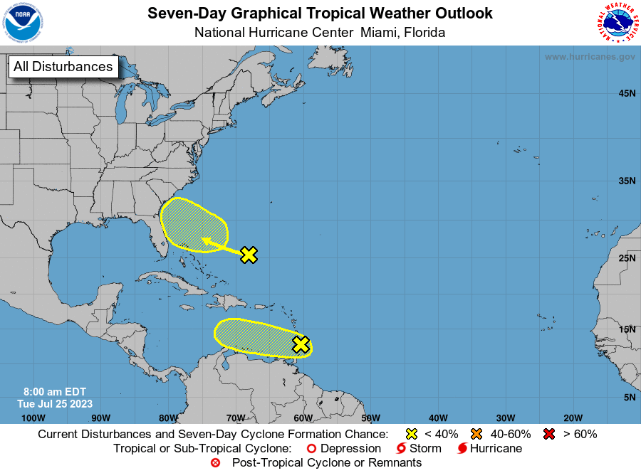
Two in the area, one just popped up north of the Bahamas and is heading toward Florida and the Georgia.
Tropical Weather Outlook
NWS National Hurricane Center Miami FL
800 AM EDT Tue Jul 25 2023

For the North Atlantic...Caribbean Sea and the Gulf of Mexico:

1. Near the Windward Islands (AL95):
A tropical wave located near the Windward Islands is producing a
large area of disorganized showers and thunderstorms while moving
quickly westward.  Development, if any, of this system should be
slow to occur during the next day or two before it moves into a
region of unfavorable upper-level winds.  Regardless of development,
locally heavy rains and strong gusty winds are expected across
portions of the Lesser Antilles during the next day or so.
* Formation chance through 48 hours...low...10 percent.
* Formation chance through 7 days...low...10 percent.

2. Southwestern Atlantic:
A weak trough of low pressure is located a few hundred miles
south-southwest of Bermuda.  Some gradual development of this system
is possible while it moves west-northwestward towards the
southeastern U.S. coast later this week and into the weekend.
* Formation chance through 48 hours...low...near 0 percent.
* Formation chance through 7 days...low...20 percent.
nhc.noaa.gov
The new system has a low chance of building but will bring rain.
A new tropical disturbance a few hundred miles south of Bermuda was detected Monday afternoon by the National Hurricane Center, making it the second currently in the Atlantic. The first disturbance is west of the Windward Islands. Those two are in addition to Don, now a post-tropical cyclone in the northern Atlantic which became the fifth longest-tracked tropical system in July. The new system is an area of low pressure but is still too weak to become a cyclone in the next couple of days. There’s a low chance it becomes a tropical cyclone in the next week as it moves towards the southeastern U.S. coast. The system east of the Windward Islands is still kicking, and still has a low chance of becoming a tropical cyclone in the next two-to-seven days.
The system closest to us was noted a week ago.
This disturbance was first noticed by the NHC last Wednesday. In an afternoon update, forecasters said the system hasn’t become much more organized than before, but that development is still possible as it moves towards the Caribbean Sea. Even if tropical cyclone development doesn’t happen, the Lesser Antilles are still in for heavy rains and gusty winds as the system passes through over the next two days. If the system doesn’t develop soon, then chances for it to strengthen will decrease since conditions for development will deteriorate by the middle of this week. This is due to Saharan dust and other factors. Don is officially a post-tropical cyclone, according to a morning update from the NHC. The cyclone has winds of 45 mph and is moving at 20 mph, and is expected to continue losing strength as it coasts over cooler waters. Don should continue to weaken and is expected to dissipate as early as Tuesday. Don first became a disturbance on July 10, near Bermuda. It briefly became the season’s first hurricane over the weekend, but quickly lost power as it moved over cooler waters. Because forecasters have been tracking the cyclone for two weeks, Don is now the fifth-longest July tropical cyclone, with the next-longest being Hurricane Emily in 2005. It did not make landfall anywhere.
nola.com
The threats, even if mild, fit nicely into this season.


