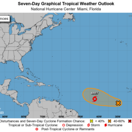
One to watch as the guess is under the islands.
Tropical Weather Outlook
NWS National Hurricane Center Miami FL
200 AM EDT Thu Jul 20 2023

For the North Atlantic...Caribbean Sea and the Gulf of Mexico:

Active Systems:
The National Hurricane Center is issuing advisories on Tropical
Storm Don, located over the central Atlantic.

1. Eastern Tropical Atlantic:
A tropical wave located a few hundred miles south of the Cabo Verde
Islands is currently interacting with the Intertropical Convergence
Zone. The combination of these features is producing a broad area of
showers and thunderstorms over the eastern and central tropical
Atlantic. While dry air to the north may prevent significant
organization during the next few days, environmental conditions
could become more conducive for some development by this weekend as
the wave moves westward across the central tropical Atlantic.
* Formation chance through 48 hours...low...near 0 percent.
* Formation chance through 7 days...low...20 percent.
nhc.noa.gov
Two on the screen but only one down here.
Tropical Storm Don is gaining some strength as it continues to swirl slowly through the Atlantic Ocean, National Hurricane forecasters said Wednesday. Meanwhile, forecasters are tracking a new disturbance off the coast of Africa. Don, located between Bermuda and the Azores, is producing maximum sustained wind speeds of 40 mph as it heads south over the Atlantic Ocean at about 5 mph, forecasters said in a 4 a.m. update. Don is expected to continue curving clockwise over the next several days before eventually heading north over cooler waters and degenerating. While forecasters said conditions are not all that conducive for extreme intensification, Don is predicted to continue gaining some strength, reaching maximum sustained wind speeds of about 50 mph within the next two days. The storm does not currently appear to be a threat to any land masses.
nola.com

Don has been tracked for 10 days.
The National Hurricane Center started tracking Don early last week on July 10. It formed into a subtropical storm on Friday. The storm weakened into a subtropical depression mid-day Sunday but regained strength and was classified as a tropical storm by about 9 p.m. Monday. Don was initially categorized as “subtropical” because it was embedded within an upper-level trough and had a relatively large radius of maximum wind, forecasters said. While tropical systems have the potential to quickly grow into hurricanes, subtropical storms do not. Don is now the fourth tropical storm to roll through the Atlantic Ocean this hurricane season.
Now the tropical wave off Africa.
The National Hurricane Center is also tracking a tropical wave near Africa, forecasters said in a 7 a.m. update Wednesday. The disturbance, located a few hundred miles south of Cabo Verde, is producing clouds and showers over the eastern tropical Atlantic. While forecasters said dry air should prevent formation during the next few days, environmental conditions could become more conducive for some development by this weekend as the wave moves west at 15 to 20 mph. Forecasters said the wave has a 20% chance of forming within the next week.
Keep the southern one in sight!


