
Farming up river uses fertilizers. This flows into the Gulf creating a “Dead Zone” with low oxygen. THis dead zone has grown to 4,880 square miles as the use of fertilizers is unabated.
he 2021 summertime “dead zone” along the Louisiana and Texas coast lines — an area of low to no oxygen that can kill fish and bottom-living organisms — is predicted to cover 4,880 square miles of the Gulf of Mexico’s water bottom, according to NOAA scientists. That’s almost as large as the five-year average size of the low oxygen zone, which is 5,400 square miles. But it’s significantly less than the record-setting 8,776 square miles of hypoxic water measured in 2017 by scientists with Louisiana State University and the Louisiana Universities Marine Consortium. Researchers will conduct their annual oxygen measurement cruise in the last week of July and the first week of August to determine the dead zone’s size. If tropical storms don’t churn up the Gulf of Mexico and mix oxygen back in before then, this year’s dead zone will be almost three times as large as the state of Rhode Island. The low-oxygen area is directly linked to the nutrients that run into the Mississippi and Atchafalaya rivers and are carried into the Gulf. The nutrients include nitrogen and phosphorus that are used as fertilizer on farmland and that come from untreated sewage in the 32 states and parts of two Canadian provinces in the watershed.
nola.com
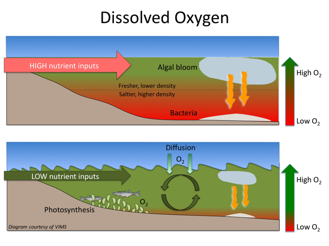
When the freshwater carrying the nutrients reaches the Gulf, it creates a layer over more dense salt water. The nutrients trigger blooms of algae that eventually die and sink to the bottom, where the use up oxygen as they decompose. That low-oxygen condition, called hypoxia, will kill bottom-living organisms, such as crabs and worms, and force creatures that can escape, including many commercial fish species, into deeper water. Scientists have also found that such low levels of oxygen reduce some fish species’ reproductive capability and can reduce the average size of shrimp.
The measurements were gathered from samples taken from the river of water entering the Gulf. The nutrient reading it compared to the flow of the river at that time to get the estimate. This year, the dead zone is 2.5 times larger than the government wants as well as state compacts. The Interagency Mississippi River and Gulf of Mexico Hypoxia Task Force has set a limit of 1,900 square miles in 1998 and renewed in 2008. THe government has spent millions to cure this ill but the restraints on the farmers is voluntary and so the onslaught of nitrogen rich water continues.
“The concentration of nitrate has been declining over the last 20 years, but the increase in river discharge means that the total loading has remained the same in recent decades or is increasing,” said LSU researchers Eugene Turner and Nancy Rabalais in their own preseason hypoxia forecast, also released on Thursday. The NOAA forecast relies on preseason forecast information gathered by its own scientists and those of the U.S. Geological Survey, and from teams at LSU, University of Michigan, the Virginia Institute of Marine Sciences, North Carolina State University and Dalhousie University. Rabalais has headed the annual monitoring cruise effort since 1985.
A map of the dead zone can be found here. In 2020 the size was 2,117 but that small size was due to Hurricane Hanna which churned us the waters. The 2020 estimate for this year was 6,400 square miles by NOAA and 7,769 by LSU. Hanna formed on July 23, 2020 just south west of the mouth of the river and moved west to Padre Island as a Category 1 storm.


