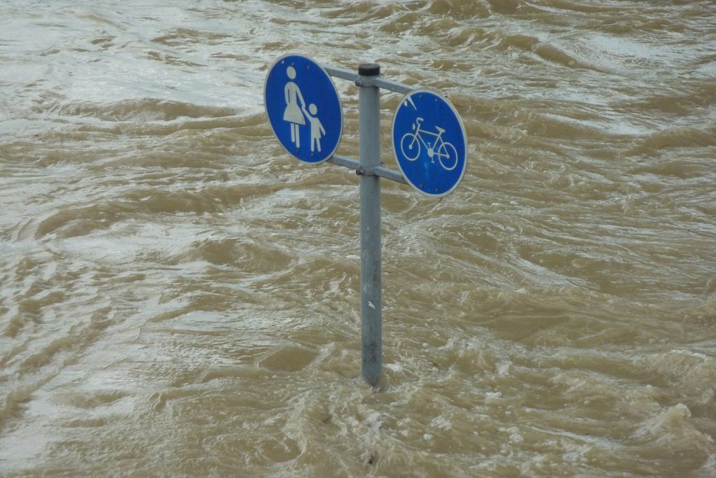
50 years and $760 million dollars is all it took to start levees for the River Parishes so they don’t look like this picture!
In 1970, River Parishes leaders who were worried that the new levee system being built in New Orleans after the devastation of Hurricane Betsy would push flooding to communities on the western edge of Lake Pontchartrain met with the Corps of Engineers to ask for greater protection. Five decades later, federal, state and local elected officials, led by Gov. John Bel Edwards, hoisted shovels full of dirt at the Reserve Relief Canal boat launch Monday morning to formally kick off the construction of the $760 million, 18.5-mile-long West Shore Lake Pontchartrain hurricane levee project, designed to protect portions of St. Charles, St. John the Baptist and St. James parishes from hurricane storm surges originating in the lake. “With the completion of the West Shore project, thousands of Louisianans and millions of dollars of residential and commercial property will receive a much deserved increase in their level of hurricane protection,” Edwards said, after the politicians retreated from the 90-degrees-plus heat to a canopied news conference space.
nola.com
The major levee, to be built from east of Garyville swinging north and east between the river and Lake Maurepas to the Bonnet Carre Spillway, will prevent the 100 year flood meaning it will be needed more often and the 100 year floods come more than every 100 years in these days of climate change.
U.S. Rep. Garret Graves, R-Baton Rouge, pointed out that efforts to gain the new levee protection predated his birth in 1972, long before LaPlace and adjacent communities were inundated in 2012 by Category 1 Hurricane Isaac. Past hurricanes, including the five that hit the state in 2020, and repeated “rain bombs” that have hit the region this year, are making people question whether they should stay in the River Parishes, he said. “Is this where I’m going to keep investing in my business? Is this where I’m going to keep my family? It’s a good question because its hard continuing to go through all these events, gutting your home, evacuate your family, having to move your business out,” he said. But, Graves said, the reason President Thomas Jefferson directed James Monroe and Jay Livingston to buy the Louisiana Territory 218 years ago — that it is essential to the nation’s future growth — remains true today. “Today’s groundbreaking marks a significant milestone for much-needed flood protection in St. John the Baptist Parish,” said St. John Parish President Jaclyn Hotard, especially for the numerous residents and businesses that will be provided surge protection when the levee is completed by the beginning of the 2024 hurricane season.
Newly installed Representative Troy Carter also commented on this program.
U.S. Rep. Troy Carter, D-New Orleans, who also represents part of the River Parishes, said the West Shore project is an example of the type of flood risk reduction projects that can be approved through nonpartisan efforts in Congress. St. Charles Parish President Matthew Jewell pointed to the Upper Barataria levee project, which will protect the west banks of Jefferson, St. Charles and St. John parishes, among others, as just such an example. It was approved for construction at the same time as the West Shore project. For St. James Parish President Pete Dufresne, the project represents a first step in flood reduction for his residents. The main levee does not extend far into St. James; instead, the project includes a small ring levee around the town of Gramercy and a U-shaped levee protecting Grand Point, plus a pot of money to pay for floodproofing or relocating some homes that remain in danger of repeat flooding.
Army Corps of Engineers
This project started in 1985 but was deemed not cost efficient and was shelved.
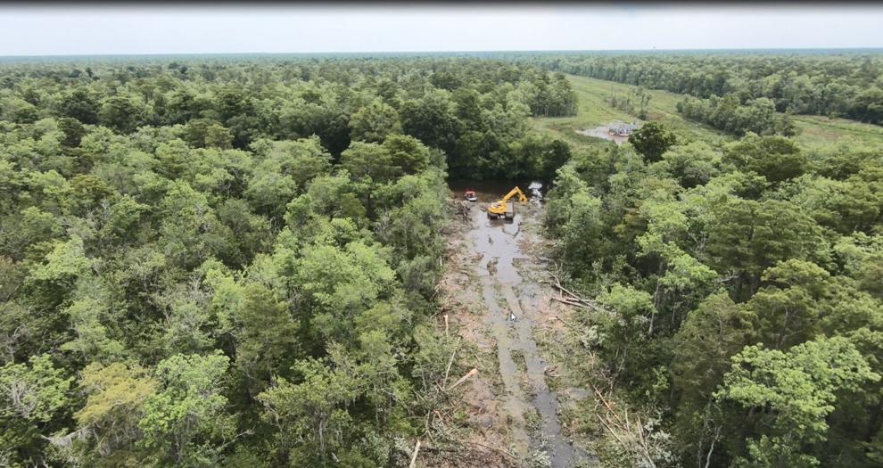
Hotard explained that the levee system’s origins date back 51 years, to that meeting between River Parishes leaders and the Corps. The Corps completed a first reconnaissance report, the first step in gaining project approval, for a West Shore levee in 1987, but the project’s costs then outweighed its financial benefits, and the project was shelved. A new reconnaissance report was completed in 1997 recommending the levee, but along a path that would have left out protection for the Interstate 10 area in St. John. The alignment was changed to include the interstate and the project was funded by Congress in 2018 under provisions requiring its completion by 2024. The groundbreaking location represents the entryway to one of a half-dozen access roads being built from Airline Highway into the Maurepas Swamp. The roads will be used to truck in sand that will be a base material, and then clay for construction of the earthen levee segments. Much of the sand and clay are being mined from the Bonnet Carre Spillway.
Some contracts have already been awarded and the clay is being stockpiled for later use.
Pontchartrain Levee District Executive Director Monica Gorman said the Corps has already awarded two contracts for stockpiling clay, one for stockpiling sand, and one for clearing 195 acres of trees along the route of the levee system, which will stretch from the western side of the Bonnet Carre Spillway to Garyville. The clearing contract was actually awarded in mid-2019 to clear a 100-foot wide path through cypress and tupelo swamp along the proposed levee footprint. Since then, Corps engineers and contractors have used that path to take samples of the soils underground to get a better idea of how to design the levee. The levee system also will include about a mile of thick T-shaped floodwalls built atop both sheet piling and long h-shaped angled batter piles, and several pump stations to allow rainwater to be pumped out of the area protected by the new levee.
The cleared area will also be used for tests to determine the best method for construction.
Col. Stephen Murphy, commander of the Corps’ New Orleans District office, said the cleared space also will be used for demonstration projects aimed at determining the best methods to build the earthen levee in the watery environment of a freshwater swamp. “Even the routes (to the levee footprint) require planning, as access currently does not exist from land,” he said.

(Army Corps of Engineers) Army Corps of Engineers)
The States involvement is mostly administrative and acting as a facilitator to link the other parties.
While the state Coastal Protection and Restoration Authority is acting as the official non-federal sponsor for the Corps construction project, it’s sharing the work of identifying and acquiring rights of way and dealing with dozens of utility crossings and pipelines with the Pontchartrain Levee District, which will operate the levee system when it is complete. Edwards said the state Legislature already has provided most of the state’s 35% share of the levee’s construction cost. Murphy said the Corps also is still considering a request by the state to use part of the state’s cost of building the Maurepas Freshwater Diversion as part of the required mitigation for environmental damage caused by the levee construction.
This just goes to show that to protect from a hurricane from the south we also need to protect from water from the north.


