
Damage from Hurricane Ida spreads throughout the damage spectrum, from total to none.
Preliminary assessments of Hurricane Ida‘s damage to Louisiana coastal projects range from “a complete wreck” to “pretty much intact.” The Coastal Protection and Restoration Authority has been taking stock of the damage in advance of seeking grants from the Federal Emergency Management Agency for repairs to restoration projects, Executive Director Bren Haase said Friday. Louisiana has had success with the process after past hurricanes. Damage to protection projects such as levees and gates might also be eligible for FEMA grants. “We’ve done a couple of overflights: Grand Isle, St. John, St. Charles, Lafitte and Plaquemines,” Hasse said. The agency also has teams of workers on the ground reviewing restoration and levee projects. “We’ve also had a preliminary damage assessment in Lafourche Parish around Kraemer, where we have moved pumps to help with dewatering, and we’re assessing the levees in St. Charles Parish,” he said. Haase said the area within the South Lafourche Levee District hurricane levee was “a complete wreck,” although the levees held. He said there was some topping of the levee at its southern tip at Golden Meadow. The Lafourche levee was built to the federal standard of a 1 percent chance of overtopping in any year, the so-called 100-year standard. Ida’s surge at the southern tip is thought to have been higher than that standard.
nola.com
Other locations were not so lucky. Some levees did not hold, other were flooded out.
NATIONAL GEODETIC SURVEY PHOTO
Elsewhere, it was clear from the aerial survey that the combined surge and waves as Ida went ashore Sunday cause significant damage in several locations. “A lot of the beach on Grand Isle was washed back onto Louisiana 1, and almost the entire ‘burrito’ levee was exposed,” Haase said. The burrito levee is a base layer of sand encased within a plastic covering beneath the earthen portion of the levee along Grand Isle’s beach. The same kind of damage was inflicted by surge and waves during hurricanes last year, and was repaired by state and Army Corps of Engineers workers before the 2021 hurricane season. “Flying over the Caminada Headland restoration area, the backwater marsh restoration work looked to be in pretty good shape,” Haase said. “There was some overwash, but the containment dike under construction behind Caminada was pretty much intact.” The Caminada Headland is part of the state’s coastline between Port Fourchon to Elmer’s Island. Contractors have built a low berm along an open water area on the north side of the headland and will fill it with sediment to create a platform high enough for marsh grasses to grow. “Lower Plaquemines Parish was under water from Alliance just south of Belle Chasse to Port Sulphur. Much of the highway was still flooded,” Haase said. The Corps has been moving pumps to drain the area between the river and back hurricane levees. “Queen Bess looked really good, but from the air it’s difficult to see some of the damage the hurricane might have caused,” Haase said. Sediment used in recent years to rebuild the island, a key rookery for brown pelicans and other water birds, might have been piled up by surge, or some of the new land might have been scoured by the surge.
There has been a lot of construction and reconstruction of levees and other flood mitigation measures.
Haase said major reconstruction underway this year of the coastline of West Grand Terre Island, just east of Grand Isle, “took a beating.” At West Belle Pass, on the west side of Port Fourchon, it was difficult to see from the air whether a continuing restoration project was damaged, although sand was visible above the water. Older inland marsh creation projects, including Turtle Bay wetlands restoration and the Barataria land bridge that runs across portions of Plaquemines and Jefferson parishes, “had water on them, but were still there.”

COASTAL PROTECTION AND RESTORATION AUTHORITY PHOTO BY BREN HAASE
FEMA is a funding source that many are looking at but first the need must be accessed.
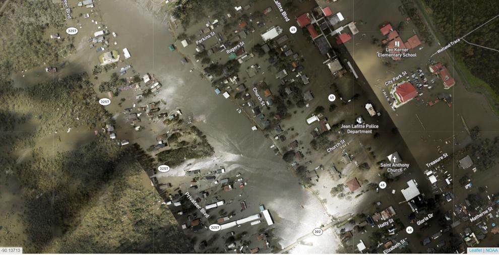
Louisiana might also apply to FEMA for money to repair damaged hurricane risk reduction projects, including levees and gates, where the coastal authority acts as local sponsor in their federal authorization, Haase said. Parishes, local governments such as Jean Lafitte and levee districts might also apply for such grants. The 7-foot-high ring levee in the Lafitte area was likely damaged when it was topped by as much as 11 feet of storm surge from Ida. “Either the Lafitte levee district or CPRA can apply for a grant for that,” Haase said. Several gates in the Morganza to the Gulf levee system, which is being built to block surge from entering the Houma area, were damaged by floodwaters inside the levee system. That resulted from the area being in the western side of Ida, resulting in it taking wind from the north, Haase said. Repairs here might also be included in FEMA grant requests. “Morganza did not overtop,” Haase said. “The winds from the north stacked up water behind the levee from within, causing electrical problems and flooding on the back side of the gates.”

Our levees held and in my neighborhood I saw only 1 house that was in bad shape. Most of us held up well or had minor damage. Outside of the city, however, things are different in many areas coupled with some not getting power back until the mid-end of the month.


