(image via NOAA)
Our first visit by weather this season and fortunately a mild one.
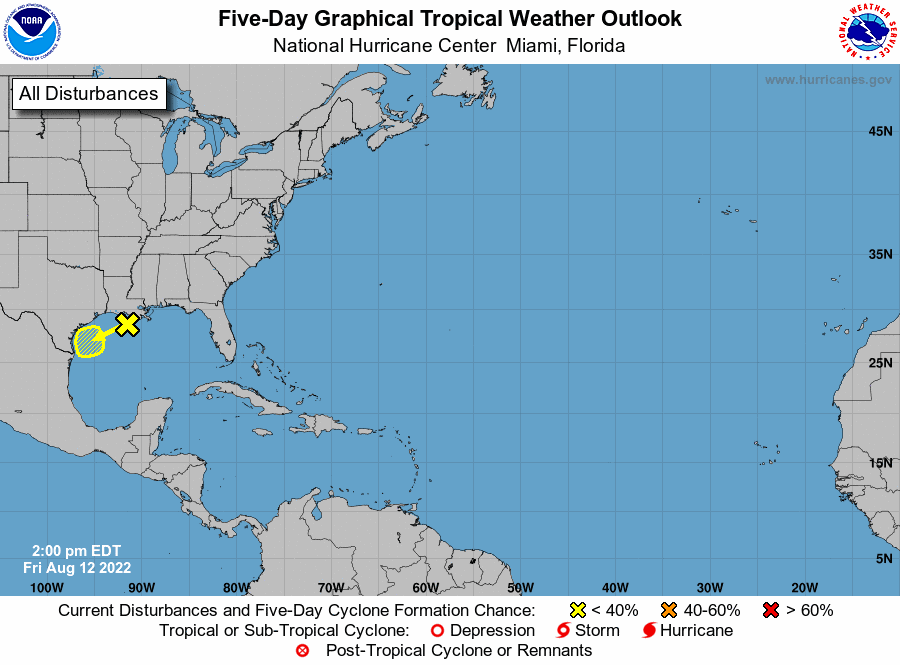
South Louisiana is expected to get rain from a tropical disturbance in the Gulf of Mexico, but the amount will vary widely depending on where thunderstorms pop up, forecasters said Friday. The system is off the south coast of Louisiana and is expected to continuing move west to Texas over the next 48 hours, according to the National Hurricane Center. It has a 10% chance of developing into at least a tropical depression. The main threat for Louisiana will be flash flooding in low-lying places and in urban areas like downtown New Orleans and downtown Baton Rouge, according to Robert Frye, a lead forecaster with the National Weather Service in Slidell. There are no widespread flooding concerns in Louisiana related to the tropical system, he said.
nola.com
Average wide there will be little rain, except in thunderstorms.
Overall, the forecasted average rain totals through Wednesday night are pretty low, coming in at 0.5 inches to 1 inch for south Louisiana. However, he said, that number could change dramatically if places are hit by a thunderstorm. “Thunderstorms are a pain sometimes because you don’t know how many are going to pop up or where they are going to form,” he said around 11 a.m. Friday. Some of the storms could dump in excess of 2 to 3 inches of rain per hour, forecasters said. That could be a problem if “thunderstorms form over you day after day,” Frye said. Heavy rain is possible through 7 a.m. Sunday in south Louisiana, with the greatest rainfall chances during the day. The rain is expected to stay over water at night. New Orleans, Slidell, the north shore and other coastal areas are at risk of flash flooding Friday. By Saturday, the risk spreads to include Baton Rouge and Lafayette, forecasters said.

It may be here until Monday
Rain chances stick around through Monday, but each day shouldn’t be a washout. Saturday is expected to be a little drier than Friday, forecasters said, and Sunday and Monday are expected to be mostly sunny with a 40% to 50% chance of rain. But, as the weather dries out, the temperatures are expected to climb higher, Frye said. The rain is welcome news for Texas, where about 96% of the state is considered to be in a drought, according to the U.S. Drought Monitor. As of 1 p.m. Friday, forecasters were tracking a lower pressure system that was center just offshore of the southern coast of Louisiana. The system has disorganized showers and thunderstorms associated with it over the Gulf of Mexico. Development, if any, is expected to be slow as it drifts southwest toward the Texas coast, hurricane forecasters said.

(image via National Hurricane Center)
We are in the stages where the storm has not developed but is disorganized.
The shaded area on the graphic is where a storm could develop and is not a track. The National Hurricane Center releases a track when a tropical depression forms or is about to form. The categories, in order of increasing strength, are tropical depression, tropical storm and hurricane (categories 1 through 5). Systems are named when they develop into a tropical storm. The Atlantic and the Caribbean are expected to be quiet for at least the next 48 hours, forecasters said.
As we enter the season with the first bit of activity we need to be ready.
We are entering what historically has been the busiest time of the Atlantic hurricane season. Now is the time to review hurricane plans and make sure your property is ready. Here are some tips from the National Weather Service for how to prepare for the season: Put together an emergency kit. Here are 60+ nonperishable items to consider including, Check emergency equipment, such as flashlights, generators and storm shutters, Make a plan with your family or close friends and decide how you will get in touch and where you will go if there’s an emergency. Here’s how to decide if you should evacuate, Plan your evacuation route and have an alternate route. Here are 15 things to do before evacuating, Make a plan for your pets. Here are some tips, If you have a generator, check it and see if any maintenance needs to be done. Don’t forget these important generator safety tips, Do any maintenance you’ve been putting off on your vehicle, Review your insurance policies, Keep your trees around your home trimmed to prevent damage from broken branches. Here’s advice from gardening expert Dan Gill and Have materials in advance to board windows to protect them from flying debris. Don’t miss a storm update this hurricane season. Sign up for our free Hurricane Center newsletter.
A lot of good ideas and all should be careful.

