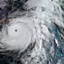
On this anniversary of Katrina and Ida in a time when nothing has hit us yet we need to keep our guard up as climate change has made the storms more intensive.
On the anniversary of Hurricane Katrina and Hurricane Ida, LSU geology professor and climatologist Jill Trepanier noted that hurricanes entering the Gulf of Mexico are becoming more intense. Whether that’s from an ever-changing climate and other environmental factors, such as the loss of mangrove trees along the coast, is at this point are matters needing more study, Trepanier told the Baton Rouge Press Club on Monday. Trepanier said the once lush mangrove trees, cut down for various uses over the years, would absorb wave energy near the coast and their disappearance is part of how storm systems like last year’s Hurricane Ida now maintain energy as they make landfall. “Now fast forward to today, the mangroves are gone and most of what’s there is swamp land or marsh land, particularly in the southwestern part of Louisiana,” she said. “In this situation, these are not as dense of trees so as to support or deflect some of that energy that comes in. In fact, it’s basically a place that’s halfway water and halfway land that helps to support the additional fuel transfer into the storm itself.”
theadvocate.com
We see daily that there are tropical disturbances in the Atlantic and Caribbean so the threat is there.
Meanwhile, with several tropical disturbances now swirling around the Atlantic Ocean, hurricane forecasters with the National Weather Service predicted Monday predict a tropical depression is likely to form in the Atlantic later this week. But now is not the time to worry that the storms will mimic the likes of Category 5 Katrina in 2005 and Category 4 Ida, which were the first- and second-most destructive storms to hit the Louisiana coast in recent memory, Trepanier said. In fact, she said she doesn’t anticipate any of the four new disturbances to cause too much trouble over the next few days. “In that region, there is literally just a couple of thunderstorms that are brewing,” she said. “If it starts to organize and makes itself to the other side of the Yucatan, it’ll officially be in the Gulf of Mexico and that’s when you should start paying attention. The reality is, all atmospheric tracking points to it making landfall in Mexico, not making it a curve up into the Gulf.” Nevertheless, Trepanier said she does expect more storms to approach the Gulf in the coming weeks. “We should always be watching, that never changes, but we are just starting to amp up into our official peak of hurricane season,” she said. “It’s in August for the entire Atlantic, but once we move into just the Gulf of Mexico, we are slightly more at risk in September or October.”
Computers can start early following the potential storms but are only accurate within a day or two. We have seen quick amplification of the storms over night and a computer may not expect that.
Because computer models are only effective at predicting the behavior of a storm up to two or three days ahead, Trepanier warned that people should begin paying attention once the storm reaches into the Gulf, pointing to the “small, unorganized cluster of thunderstorms” surrounding the Gulf currently. The research Trepanier conducts on hurricanes involves studying “rapid intensification events,” which occur when wind speeds increase by 35 knots, or just over 40 mph, in a 24-hour span. Unlike before, when hurricanes used to weaken as they approached land, they now increase in strength much closer to the coastline and cause more damage as a result. “So usually a storm starts to die out, but now it’s starting to increase,” Trepanier said. “This is not always, but if a storm has the conditions available to rapidly intensify, it will do so even in 40 meters of warm water right next to a coast. So that normal response that we see of it decaying as it moves inland, it’s not doing that as fast as it used to, which then leads to a higher level of destruction.”
Theefarther you get from the Gulf the weaker the storm which makes sense.
In cities like Baton Rouge that are farther inland from the Gulf than New Orleans by comparison, storms are usually not as strong, though they have been increasing in intensity in recent years. “We rarely see Category 1 storms last above the I-10 line, but yet, we see them more today than we did before,” she said. “Is it related to a changing climate? I don’t know the answer to that yet, but we are actively trying to figure it out.” Trepanier said Earth will eventually balance itself out, but we’ll have to make do with the new normal of stronger hurricanes for the foreseeable future. “The planet will equalize itself and it’ll find a way to get cold again, think melting ice caps and shutting off circulation patterns,” she said. “While we’re trying to reach some state of equilibrium, we are experiencing new normals. This idea of really impressively and rapidly intensifying hurricanes, they’re growing and they’re becoming beasts faster than they ever used to.”
So, the answer is to plant more mangrove trees? That is probably the cheapest option and if done over time the barriers will be back.


