
(Image via National Hurricane Center)
The NHC is watching a couple that may come close and others that are far away and getting farther away.
A tropical depression is likely to form within a few days in the Caribbean Sea, hurricane forecasters said Wednesday morning. The system is worth “watching closely,” forecasters with the Slidell office of the National Weather Service said. However, it’s still maybe a week away from the Gulf of Mexico — if it makes it that far — and environmental conditions can change. The disturbance is currently called Invest 98-L and continues to show signs of organization, according to the latest forecast from the National Hurricane Center. It has a 90% chance of developing into a tropical depression within five days. It will most likely be named Hermine if it strengthens into a tropical storm.
nola.com

5 systems in the Atlantic
Hurricane forecasters also are tracking four other systems in the Atlantic: Hurricane Fiona, Tropical Storm Gaston, Disturbance off the coast of Africa and Disturbance in the Atlantic. Hurricane Fiona, Tropical Storm Gaston and the disturbance by Africa’s coast don’t pose a threat to Louisiana. It’s too early to accurately say where the Caribbean disturbance could go if it develops. The next storm names are Hermine, Ian and Julia if any of the disturbances strengthen into a tropical storm. Here’s what to know about the tropics as of 10 a.m. Wednesday from the National Hurricane Center.

Disturbance heads toward Caribbean
The disturbance heading toward the Caribbean — Invest 98-L — was a couple hundred miles east of the southern Windward Islands early Wednesday. It’s moving west at 15 to 20 mph and is expected to cross the Windward Islands later Wednesday and then enter the Caribbean, forecasters said. It has a 70% chance of developing into a tropical depression within 48 hours and a 90% chance of development within five days. The disturbance is expected to bring heavy rainfall and gusty winds to parts of the Windward Islands, Venezuela, Colombia and the ABC island chain this week, regardless of development. It’s too early to tell if the system could reach the Gulf of Mexico and eventually be a threat to Louisiana. Now is the time for Louisiana residents to review their hurricane plans and make sure their supply kits are prepared for the rest of hurricane season, forecasters with the National Weather Service in Slidell said Wednesday. The shaded area on the National Hurricane Center graphic is where a storm could develop and is not a track. Hurricane forecasters release a track when a tropical depression forms or is about to form. The track shows where the storm could go within five days. Long-range models show predictions up to 16 days in advance and change frequently. They are not reliable at forecasting landfall 7 to 10 days in the future. However, they are helpful in giving a general idea about what could happen. Some of the long-range model runs from the Global Forecast System have shown the system entering the Gulf of Mexico next week. But, it’s too far in the future to predict anything accurately. Forecasts will become more reliable if the disturbance actually forms. The categories, in order of increasing strength, are tropical depression, tropical storm and hurricane (categories 1 through 5). A system is named when it develops into a tropical storm.
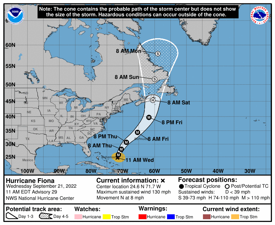
Hurricane Fiona strengthens in Atlantic
Hurricane Fiona has strengthened into a Category 4 storm in the Atlantic as it heads toward Bermuda and eventually Nova Scotia and Prince Edward Island. It is not currently expected to make landfall on the U.S. mainland. As of 10 a.m., it was about 675 miles southwest of Bermuda and about 1,455 miles southwest of Halifax, Nova Scotia. It’s moving north at 8 mph and is expected to approach Bermuda on Thursday and Canada late Friday. It has winds of 130 mph, and additional strengthening is expected through Wednesday night. Fiona is forecast to have peak winds of 140 mph, which would make it a powerful Category 4 storm. Category 5 storms have winds of at least 157 mph. The storm has been blamed for directly causing at least four deaths in its march through the Caribbean, where winds and torrential rain in Puerto Rico left a majority of people on the U.S. territory without power or running water. Hundreds of thousands of people scraped mud out of their homes following what authorities described as “historic” flooding.
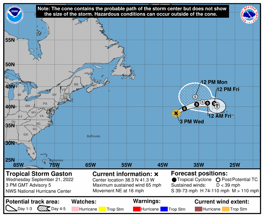
Tropical Storm Gaston could strengthen.
Tropical Storm Gaston was moving through the open waters of the Atlantic and is expected to stall near the Azores later this week. No watches or warnings are in effect, but forecasters said residents in the Azores should monitor the storm. As of 10 a.m., Tropical Storm Gaston was about 775 miles west of the Azores and was moving northeast at 35 mph. It has winds of 65 mph, and some additional strengthening is possible Wednesday before gradual weakening begins Thursday. The current 5-day forecast does not have it strengthening into a hurricane.

Disturbance by Cabo Verde Islands
Hurricane forecasters also are tracking a disturbance that’s several hundred miles southwest of the Cabo Verde Islands. It’s expected to move northwest and then west. Shower and thunderstorm activity increased Wednesday morning, and forecasters said some slow development is possible over the next several days. The disturbance has a 30% chance of developing into a tropical depression within five days.

Tropical depression could form
Another tropical depression could form this weekend in the Atlantic, forecasters said. The disturbance is currently a tropical wave that’s expected to move off the west coast of Africa on Thursday. Environmental conditions appear favorable for some development, forecasters said, while the system moves slowly north between the west coast of Africa and the Cabo Verde Islands. The system has a 50% of developing into a tropical depression within five days.
So, one which looks like may come, another that may or not come and one that has not developed yet. So the pace is quickening and we can’t miss all of them, but maybe we can!


