CPRA
We have the choice, Pay to have coastal projects or pay billions in damages.
Louisiana could see more than $31 billion a year in storm surge damage under worst-case predictions of sea level rise if it fails to adopt new projects for its 2023 coastal Master Plan, state officials warned Thursday. The warning came as the state’s Coastal Protection and Restoration Authority held an online hearing on the update of its Master Plan, which lays out the state’s strategy for fighting land loss. And even if the state adds the more than 130 projects being considered for inclusion in the master plan, Louisiana’s coastline remains on track for continuing dramatic land loss.
nola.com
We have lost thousands of square miles of coastal land mostly due to oil (but remember they bring jobs).
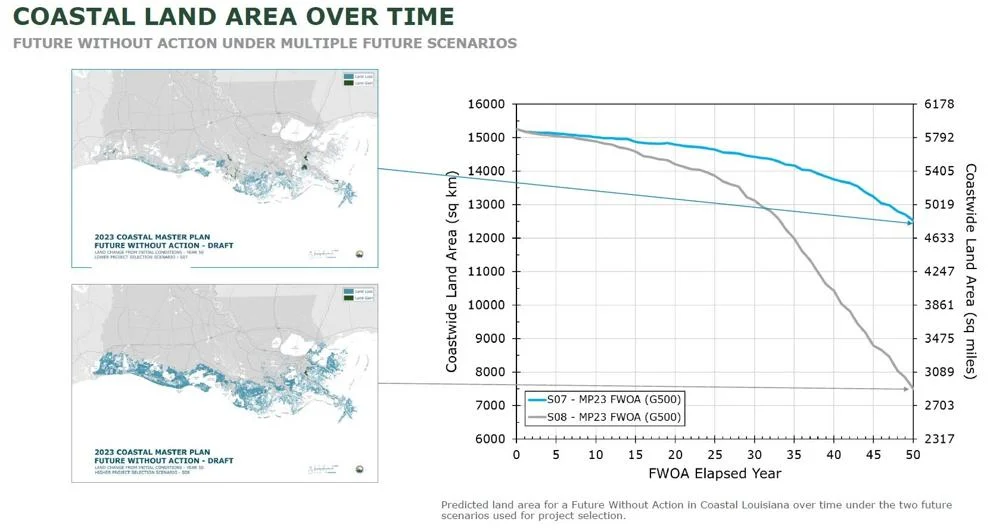
The state has lost more than 2,000 square miles of its coast since the turn of the 20th century. That loss is due to a range of human-induced factors, including the Mississippi River levees preventing sediment from reaching wetlands and the dredging of thousands of miles of navigation and oil-and-gas exploration channels. Other causes include invasive nutria feeding on vegetation helping hold marsh together. Another 2,000 square miles could be lost over the next 50 years, said Stuart Brown, who is overseeing the plan rewrite for the authority. Much of that loss could occur if a worldwide failure to reduce greenhouse gases resulted in a higher level of sea level rise, about 3.9 feet. A lower-level estimate used in the plan foresees 1.3 feet of sea level rise by 2073. The Master Plan, first approved unanimously by the Louisiana Legislature in 2007, provides the state with an ongoing 50-year, $50 billion agenda, using the latest information on land loss, sea level rise, coastal population trends, and other factors. The plan is now updated every 6 years.
(Coastal Protection and Restoration Authority)
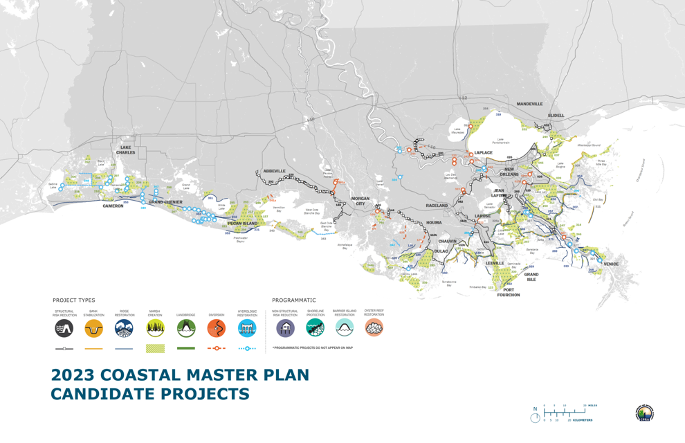
There are 131 projects in the plan and all are needed, some interlocking others.
The 131 projects now under consideration for addition to the plan include 113 to restore wetlands or other land features along the coast as well as 18 structural projects like levees and gates that will reduce the risk of hurricane storm surge flooding. The state also is evaluating a number of “nonstructural” risk-reduction projects – elevating homes, floodproofing businesses, or buying out homes in flood-prone areas – in more than 300 coastal communities, Brown said. Those projects are being developed from proposals submitted to the authority by local governments, individuals and the authority’s staff since October 2018. Five regional working groups of state and local officials have been developing and refining individual projects since 2018. The state uses a suite of computer models to study and compare individual projects based on their effectiveness and costs, and then the projects are modeled again in groups to determine which ones work well with each other. A final list of projects will be presented during eight in-person community roundtables across the coast in November, while a final draft will be the subject of public hearings in New Orleans, Houma, Baton Rouge and St. Charles in January 2023. The coastal authority board will vote on a final version of the plan in March before presenting it to the Legislature in April.
(Coastal Protection and Restoration Authority)
The computers have been updated with the recent information on past hurricanes to show the changes from the past.
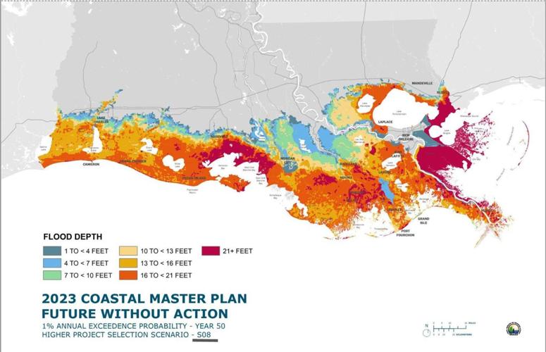
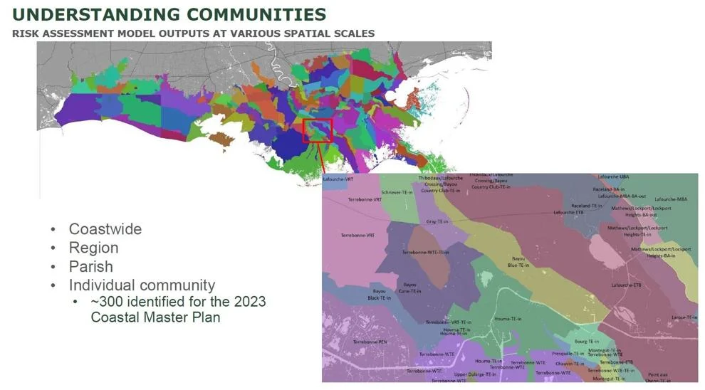
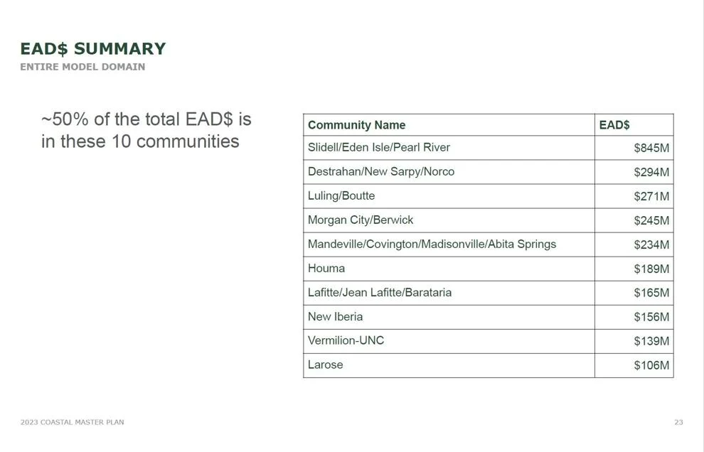
As part of the plan rewrite process, scientists have updated models showing how hurricanes strengthened by global warming will affect the coast over the next 50 years. There is also a risk model to determine both the overall costs of damage from surge and the loss of wetlands, as well as a separate accounting of structure damage that is not weighted by building costs, in an effort to assure selections are fair to low-income and other smaller communities, Brown said. The authority developed a series of predictions of what will happen without construction of new projects. That modeling has produced chilling estimates of both the potential for land loss and damage to communities. A top-10 list of damages after 50 years — assuming no action is taken — indicates that the Slidell-Eden Isles-Pearl River communities would be the most affected in 2073. The models show an estimated $845 million a year in possible damages there from the effects of storm surge caused by a hurricane with a 1 percent chance of occurring in any year, a so-called 100-year storm. Even using a lower sea level rise scenario, 100-year surge heights in the Slidell area are estimated to be between 16 and 20 feet. The higher sea level scenario predicts water levels in some parts of the Slidell area of greater than 21 feet.
The list of the projects is not available but the locations are.
The authority was unable to provide a detailed list of coastal restoration projects on Thursday, beyond a map identifying the types of projects and where they would be located. The structural protection projects being considered include: Ring levees for Slidell, already being considered by the Army Corps of Engineers as part of a separate study, A plan to elevate levees in the greater New Orleans area. State and local levee officials have urged the Corps to consider elevating the levels to protect from at least a 200-year surge event in the future. The Corps already has been authorized to spend $3 billion over the next 50 years to keep the levee system at its present 100-year levels, A “Lake Pontchartrain Barrier” project, which would add storm surge protection to the Rigolets and Chef Menteur passes, reducing surge heights in the lake, Additional storm surge protection in St. James and Ascension parishes, Several improvements to hurricane levees along the Mississippi River in Plaquemines Parish, Additional ring levee protection for Lafitte. The area already has been funded for lower levees to protect against high-tide flooding under the existing plan update, Several improvements to hurricane levees along the Mississippi River in Plaquemines Parish, Additional ring levee protection for Lafitte. The area already has been funded for lower levees to protect against high-tide flooding under the existing plan update, Upgrades for the Larose to Golden Meadow and Morganza to the Gulf levee systems in Lafourche and Terrebonne parishes and A New Iberia/St. Mary Parish upland levee.
(Coastal Protection and Restoration Authority)
Remember public comments are being sought.