
The Mississippi River waters are lower than normal and it is coupled with a salt water wedge that is making it worse.
The Mississippi River is at its lowest level in a decade, with levels at the Carrollton Gauge in New Orleans measuring just 3 feet above sea level, and the mighty river’s feeble flow is wreaking havoc on shipping traffic as well as drinking water supplies below the city. The river is so low that officials with the Army Corps of Engineers last week announced a plan to build a 45-foot-tall wall across the bottom of the river to prevent a “wedge” of saltwater from moving upstream toward water intakes. The corps had to take a similar measure in 2012 — the last time the water was so low — as well as in 1999 and 1988. During times of high water, typically in springtime, the river’s surface is much higher. The corps begins its “flood fight” protocols when the surface is 11 feet above sea level; in 2020, the river was at that level or higher for six months. Floodwalls and levees protect New Orleans to at least 22 feet above sea level.
nola.com
The salt wedge is already impacting drinking water down river from us.
In lower Plaquemines Parish, where the salt wedge is already affecting drinking water, an effort to desalinate river water has been knocked off course by Hurricane Ian. A reverse osmosis unit the parish was trying to lease for its Boothville drinking water treatment plant on the river’s east bank has been delayed for at least a week after the unit was rerouted to a water plant in Florida hit by Ian, a parish official said Tuesday. “That first unit was deployed to Florida, so now a unit in Texas is being refurbished with new membranes, and we’re hoping for it to be installed no later than next week,” said Patrick Harvey, director of the parish Office of Homeland Security and Emergency Preparedness. The unit may actually be installed as early as this Friday, if all goes well, he said. Entergy is already installing a new electric pole and wiring at the Boothville facility to energize the unit. A second unit is expected to be deployed in the Pointe a La Hache water treatment plant on the west bank in a few weeks, he said. A drinking water advisory remains in effect for residents using water from the Boothville facility from the Empire Bridge to Venice because of high levels of sodium and chlorate in the water.
The lack of rain both here and up river is what is causing the problems.
The saltwater is moving up the river from the Gulf of Mexico because of a lack of rainfall this spring, summer and fall in the upper Mississippi, Ohio and Missouri river valleys. The Mississippi’s low flow allows saltwater to creep slowly north beneath the river’s fresh water. The leading “toe” of that wedge was at mile marker 47.9 on Tuesday, just below the Pointe a La Hache water intake, and had slowed in its move north, according to Ricky Boyett, a spokesman for the New Orleans District office of the Corps. But he said it hasn’t slowed enough to cancel the Corps’ plan to build a 1,500-foot-wide “sill” across the river bottom near the Phillips66 Alliance Refinery. The sill will block saltwater from moving north far enough to affect Plaquemines’ larger Belle Chasse and Dalcour water treatment plants. The levee also will prevent saltwater from moving farther upriver, where it could threaten industrial and New Orleans water intakes.
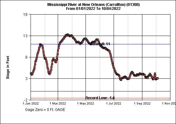
g, from Jan. 1 to Oct. 4, 2022. The record low at this location, the red line, was minus 1.6 feet, set on Dec. 27, 1872. The blue line identifies the 11-foot water level, considered “bank full” at that gauge.
This lowered status also impacts shipping.
The U.S. Coast Guard also has been warning shippers of potential risks from low water. An advisory issued Sept. 23 warned commercial vessels to be wary of shoaling – the growth of sediment in shipping channels – as far north as mile marker 167.5 above Head of Passes, in St. James Parish. And the Coast Guard announced Tuesday that it had responded to eight barge groundings upriver over the past week due to low water levels, including near Stack Island, Mississippi, and in Memphis, where waterway restrictions were put in place. In the New Orleans area, the proposed sill is expected to become an obstacle for ocean-going vessels using the channel, as ships would only be allowed to have a draft of 45 feet to pass over it, instead of the 50-foot draft allowed after the river was recently deepened from New Orleans to the river’s mouth. That will require ships to either be loaded with less cargo or to transfer cargo to other ships or barges south of the barrier. Well north of Louisiana, similar shoaling has forced barges being allowed to load smaller amounts of cargo, including soybeans that would normally be transferred to ocean-going vessels in LouisianThe result is a double-whammy affecting both upstream grain elevators and soybean farmers, he said. There’s been a 41% increase in barge shipping rates this year over last year, and some farmers are being turned away by elevators because the lack of barges has meant elevators have remained full for longer, he said.a for shipment overseas, said Mike Steenhoek, executive director of the Soy Transportation Coalition. The narrowed waterways in the upper basin also have resulted in fewer barges being allowed to be strung together, he said. “Barge flotillas normally have 35 to 40 barges strung together,” he said. “Now the maximum allowed is only 25 due to channel widths.” And lower depths on parts of the river system have resulted in individual barges being required to hold a foot or two less of soybeans. That can reduce a load of cargo by about 10%, Steenhoek said.
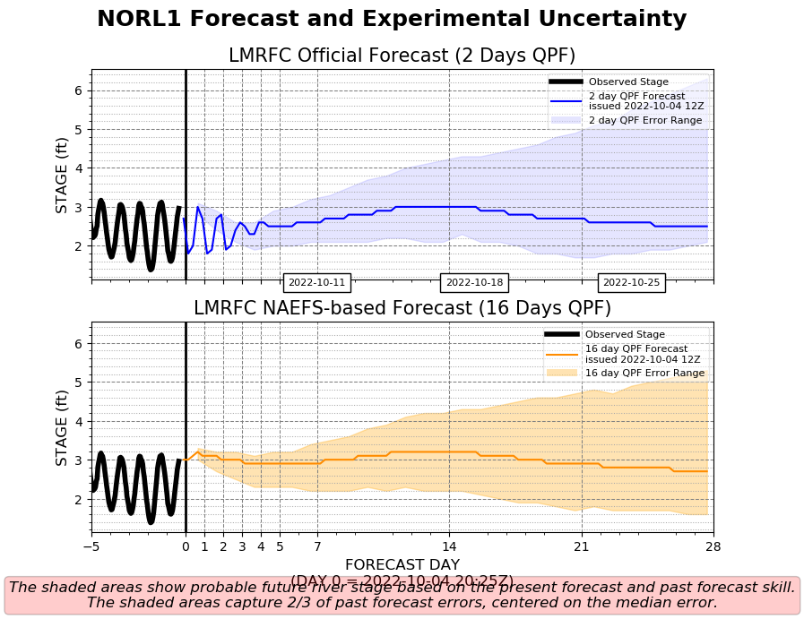
The level is expect to rise a bit in the near future.
There is likely to be a slight increase in the river’s flow next week, in part the result of up to 3 inches of rain that fell in the Ohio River basin over the weekend as a result of Hurricane Ian, said Jeffrey Graschel, a hydrologist with the National Weather Service’s Lower Mississippi River Forecast Center, based in Slidell. But that water likely won’t make it this far south on the river for another week or two, and there’s no other rainfall expected over the next 16 days, he said. The result is that once that blip passes through the New Orleans area, the river is likely to continue to drop or at least stay as low as it is now well into November. Officials with the New Orleans Sewerage & Water Board said the city’s east and west bank water intakes are low enough in the river not to be affected by the unusually low water levels that are occurring in the city itself. And the sill, once complete, should keep the city safe from the saltwater moving upstream.
This dryer weather is not helping the River!


