The Mid-Barataria Diversion is ambitious. It just got a boost from a new study that looked at two smaller but similar projects.
Louisiana’s hugely ambitious plan to rebuild part of its coast by diverting sediment from the Mississippi River has been the subject of intense debate. A new study may bolster the case of those in favor. The study looks at two smaller-scale projects that are in some ways predecessors to the Mid-Barataria Sediment Diversion, the $2 billion plan to slow land loss erasing Louisiana’s coast. Construction on that project could begin as early as next year, while a similar one on the opposite side of the river known as the Mid-Breton Diversion could follow. Its main finding is that the two existing river diversions built to increase the flow of freshwater into Barataria Bay and Breton Sound to improve public oyster grounds did not cause significant land loss. The study by researchers with Louisiana State University and the U.S. Geological Survey looked at nearly 20 years of land elevation information. While that may seem to be neither good nor bad news for the far-larger projects on the way, it refutes an earlier study held up by opponents of the future diversions as proof they will not work.
nola.com
The study, which has received peer review, shows that the smaller diversion built land.
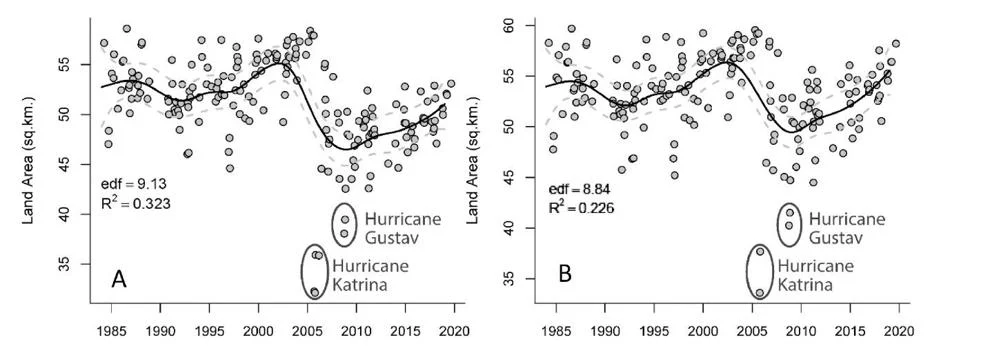
The peer-reviewed study found that the Davis Pond Freshwater Diversion on the west bank of the Mississippi River between Luling and Ama built 1.32 square miles of new land during the past 20 years, mostly within a holding basin in northern Barataria Bay where the water is first discharged. Operation of the Caernarvon Freshwater Diversion on the river’s east bank just south of Violet over 20 years was found to result in “no statistically significant” change in land area where it empties into the northwestern portion of Breton Sound, despite significant erosion in the sound’s outermost wetlands caused by Hurricanes Katrina, Gustav and Isaac. “It is clear from this study and others, that river reconnection can increase or, in the case of Caernarvon, have no statistical effect on the land change in these systems due to differences in vegetation, hydroperiod (the time that soils are saturated with water), sediment delivery and external factors including hurricane impacts,” the study concluded. The study was co-authored by LSU oceanography and coastal sciences professors John R. White and John W. Day Jr., and USGS geographer Brady Couvillion, and was published in the recently issued January 2023 edition of Ecological Engineering.
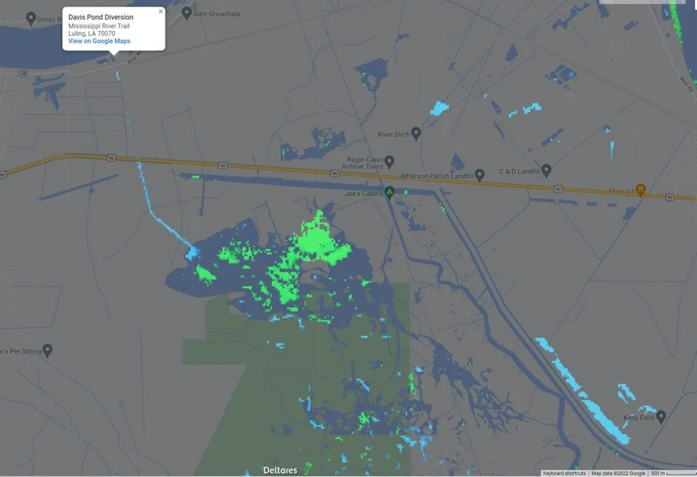
(Deltares Aqua Monitor/Google Earth)
The researchers have studied land loss for twenty years and so this new study comes with authority.
White and Day have been conducting research on Louisiana’s coastal erosion for decades. Couvillion has authored several studies using satellite and on-the-ground data for the USGS to detail the rates of coastal land loss. In a 2017 paper, he found the coast’s loss rate had slowed between 2010 and 2018 to an average of a football field every 100 minutes. This new study’s findings directly contradict a 2019 study by different LSU researchers, led by coastal sciences professor Eugene Turner, that concluded both diversions caused more land erosion than land restoration. The new paper, and Couvillion in an interview, said Turner’s study inappropriately used USGS data from one of Couvillion’s earlier studies in determining loss rates for both diversions, resulting in inaccurate land measurements. The older paper also did not count land gained in Big Mar, a failed agricultural field into which the Caernarvon diversion empties and has been building land, the new study said. But equally important, Couvillion said, is that Turner’s paper does not adequately address the difference between the two freshwater diversions and the new diversion plans that will be designed to capture sediment to build new land. “First and foremost, I think the primary issue (with the Turner paper) is that Davis Pond and Caernarvon are freshwater introduction diversions,” Couvillion said. “They were not designed, nor are they operated to effectively capture and distribute sediment.”
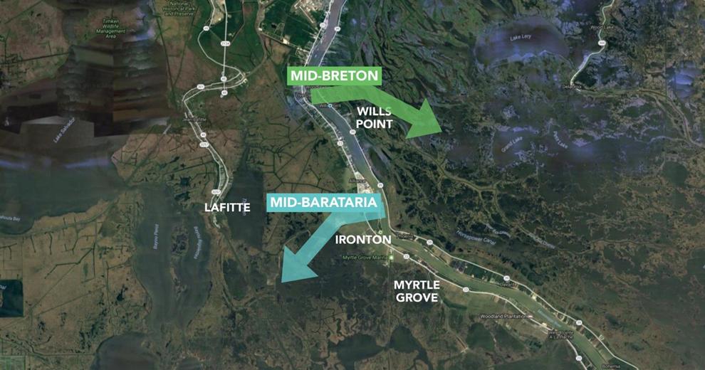
Coastal Protection and Restoration Authority
The two other diversions never got to the projected water flow but operated at one-fifth of it.
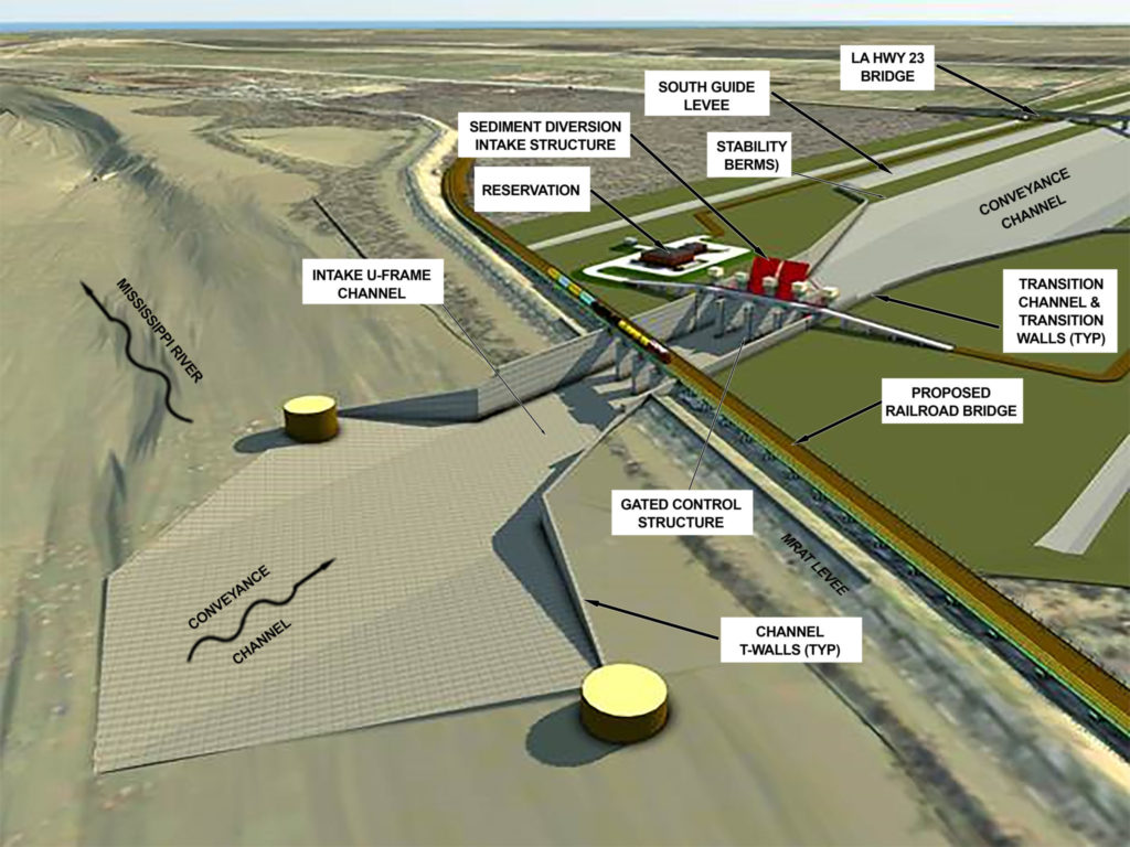
The two freshwater diversions were designed to deliver as much as 10,000 cubic feet per second of freshwater taken from the upper level of the Mississippi River as it flows by, but both have rarely been operated at more than 2,000 cubic feet per second. Those two diversions were designed to freshen water at the far ends of their prospective basins to support the operation of public oyster seed beds. While it was hoped both would also improve the health of wetlands and grow new land, because of federal rules in place at the time, permit approvals were largely based on the dollar value of improvements in the oyster beds being designed to outweigh the cost of the diversions. The Mid-Barataria diversion has been touted as a land-building tool, and is being designed to capture as much sediment as possible, with an intake structure that will reach lower levels of the river where more sediment is carried. It will deliver 75,000 cubic feet per second of sediment and freshwater into the Barataria Basin near Myrtle Grove. The project is awaiting a final decision by the Army Corps of Engineers on whether to issue operating permits, following the release of a final environmental impact statement earlier this year.
(Army Corps of Engineers)
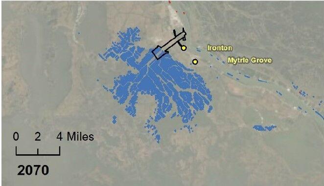
The study agreed with the estimate of the new land but it will also help wetlands.
That environmental report agreed with the project’s design team that it will create about 20 square miles of land during its first 50 years of operation, while also increasing the lifetime of both existing wetlands and new wetlands built by the state through dredging and pumping of sediment from the river through pipelines. Turner, however, still says his study provides a more accurate portrayal of the two diversions as causing land loss in the two basins. He said the new paper fails to compare land gain and loss from the diversions to areas without diversions. He also said the area reviewed in the new paper for Davis Pond was 15% smaller and for Caernarvon was 33% smaller than the corresponding areas in his paper. However, the new paper also cites similar results for land gain in the basins of the two diversions between 1985 and 2016 measured by the Netherlands-based Deltares water research program with its Aqua Monitor, which uses satellite imagery to map changes in water coverage around the world. And Couvillion said Turner’s paper was still flawed because the data it used from his earlier paper was not meant to be used for the analysis of long-term trends. The data used by Turner came from satellite imagery with a resolution of 30 meters, he said, meaning each pixel or dot on the satellite photo is 30 meters on each side, about the same size as an average residential lot. “It would be somewhat like measuring the diameter of a hair with a ruler,” he said. “It is simply the wrong tool for the job.”
(Graphic courtesy Elsevier Ecological Engineering)
Wetland environments are not stable but are ever changing.
And wetland environments are always changing, meaning comparisons of single views of the wetlands to determine trends can be problematical. “If one were to produce an estimate of coastal wetland area in Louisiana from satellite images taken today, and another tomorrow, the estimates would be different,” he said. “It is more appropriate to provide multiple estimates of wetland area and use statistical analysis to provide not only a mean, or fitted, estimate of wetland area on a specific date, but also, and importantly, an uncertainty range of your estimate.” The new paper used estimates of wetland area at smaller than pixel sizes, based on almost 200 satellite observations in a statistical analysis of wetland change based on pre- and post-diversion operations to come up with both the estimated land gain and an estimate of the uncertainty of that measurement. Couvillion also disagreed with Turner’s contention that the diversion area changes should have been compared to a “control” area, arguing there often is no suitable control area for comparison, in part because many other factors come into play as causes of erosion.
Dueling professors or is it the new guard taking over. But they both can’t be right.


