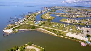
Eden Isles sits on the Lake and floods. But they will not get a levee but suggestions will be made on how to do better.
nola.com
A 16-month review of a proposed $4 billion Army Corps of Engineers plan to reduce flood risk in St. Tammany Parish is still not likely to include 100-year levee protection for Eden Isles and other small communities just south or east of Slidell, the project manager for the plan says. That’s because the high costs of expanding the U-shaped levee planned for the Slidell area would be more than the projected benefits, said project manager Amy Dixon, during a briefing at a recent board meeting for the state Coastal Protection and Restoration Authority, held in the St. Tammany Parish Council chambers in Mandeville. And that would block the entire project from being recommended for funding by Congress, she said. During the discussion that followed her presentation, coastal authority Chairman Chip Kline said the authority is willing to work with parish officials to find a way – outside of the Corps project and its federal funding – to pay for construction of a lower levee for at least the Eden Isles community, on the lakefront just south of Slidell, and possibly for other communities to the east of Slidell. Kline said the state already has set aside $9 million for projects in the parish from the state’s share of federal Gulf of Mexico offshore oil and gas revenue, and that would be available to at least study the feasibility of building the smaller levees.

The smaller levees would still offer some protection.
Those levees would be designed to protect against storm surges caused by hurricanes with a 2-percent chance of occurring in any year, a so-called 50-year flood event. The state has already funded similar higher-risk levees in other areas, such as the Jean Lafitte community. The actual cost of constructing the lower levees would not be known until initial design work is completed. The coastal authority has made clear its commitment to reducing the costs of flooding in St. Tammany Parish. As part of its 2023 revision of the state’s coastal Master Plan, officials estimated that without additional risk reduction, the Slidell/Eden Isles/Pearl River region would see an estimated $845 million a year in losses from flooding caused by a hurricane with a 1% chance of occurring in any year, the so-called 100-year event. That’s the highest damage level expected in any region of the state. The draft version of the Corps St. Tammany flood risk reduction project, completed in 2021, also called for elevating or floodproofing as many as 8,500 structures that now sit at elevations that would be flooded by a 50-year event, based on sea level conditions in 2032. Floodproofing can mean a range of solutions, such as coating walls with sealants, though no buyouts are envisioned. The project also includes snagging and clearing of Bayou Patassat and channel improvements for Mile Branch. Including the buildings that would be protected by the Slidell area levee, the project would provide risk reduction for 15,800 structures, which would represent an average of $126.5 million a year in flood damage reduction, according to the Corps draft plan.
The project is still better than doing nothing by a 1.8:1 margin.
Dixon said that halfway through the review of the draft plan, officials have determined that the benefit-to-cost ratio for the entire project is 1.8 to 1. “We did the math for many of the alternative alignments (including Eden Isles and other communities within the levee system), and they did not equate to 1 to 1 (benefits to cost) calculations,” she said. “Our chiefs tell us at every meeting that getting close to 2.0 will get you the funding you need to construct.” If the ratio drops below 1 to 1, a negative benefit-to-cost ratio, “we cannot recommend that plan” for review by officials at the Corps Mississippi River Division or the national Corps headquarters. Dixon said the 16-month, $1.8 million expansion of the original 3-year flood project design study did result in extending the original 16.3-mile U-shaped combination of levees and floodwalls around the south and west of Slidell to 18 miles, with some segments to be built to 21 feet above sea level. She said that while Corps planners also are reviewing the water heights associated with 19 different flood sources throughout the parish as part of a review of the project’s “nonstructural” feature – building elevations and floodproofing — she doesn’t expect the total number of structures to change much.
Elevating and flood proofing are the main ways to help.
The 2021 version called for elevating 6,643 residential structures up to 13 feet above sea level, and flood proofing to up to 3 feet about 1,855 nonresidential structures that won’t be projected by the new levee or the bayou clearing projects. But Dixon also delivered some good news for the elevation and floodproofing projects. Often, the individual elevation and floodproofing projects require the building’s owner to pay part of the cost, she said, even if the projects are also subsidized by grants arranged by the parish or state. “But this would be a federal project, executed with CPRA, and hopefully, at no cost to the homeowner,” she said. The state will be required to pay 35% of the entire project, including the levee and building elevations and floodproofing, as well as future operation and maintenance.
Protection comes in many flavors.


