Neptune Pass build land. Why close it and stop this action?
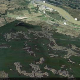
Suppose your boat was sinking and a passing craft tossed you a lifeline. How would you feel if the Coast Guard came along and cut the line? That’s pretty much how Richie Blank feels about a coming decision by the U.S. Army Corps of Engineers that could dramatically reduce or shut off Neptune Pass. This natural opening in the eastern bank of the Mississippi River across from Buras has grown from little more than a ditch into a diversion researchers say could build more than 3,000 acres of new wetlands in the next few years. For Blink, an Empire native who has spent years trying to prevent the Gulf from swallowing what’s left of sinking Plaquemines Parish, Neptune Pass should be considered part of a solution, not a problem. “The state is spending billions to build new wetlands to keep the Gulf out, and here we have nature doing it for free, but we’re rushing ahead with plans without really studying this,” he said. “It doesn’t make sense.” As always, the Corps has its reasons.
nola.com
The Corps has to keep the water pass at depth so it can be used.
By law its first responsibility is keeping the channel deep enough for commercial traffic, an economic linchpin for Louisiana and 30 other states. Any opening in the riverbank reduces the current below it, resulting in slower water speeds which allow more sediments to begin falling out, creating sand bars. When Neptune Pass (named for a community that once existed at the site) grew dramatically after the 2019 high river, it went from an afterthought to a problem — and a solution. The problem is that the Corps now faces extra dredging it says is needed to keep the channel open for shipping. “Neptune grew from about 200 feet wide to 800 after 2019, and at high levels it was moving about 120,000 cubic feet per second,” said Alex Kolker, a researcher and assistant professor of a coastal geology at the Louisiana Universities Marine Consortium. “That made it one of the 15 largest rivers in the world by volume, and actually larger than what’s planned for the Mid-Barataria Diversion.” But that size also presents some solutions that are critical not just to the economic lifeblood of the region — but its life. New wetlands built since the opening are now crowded with willow forests and marsh plants. Cattle are grazing in places that Blink said were below the water just a year ago. And Kolker’s research team has documented 3,000 acres of sediment fields rising to 6 inches below the surface of nearby Quarantine Bay that was 6 to 8 feet deep just three years ago. “We’re not finished our research yet, but there’s tremendous potential for more land building in that area,” he said. “A lot will depend on what the Corps decides to do.”
The CPRA tried to help but were refused.
The state Coastal Protection and Restoration Authority said it offered to help with that by paying for dredging while research is underway. But it said the Corps refused, claiming the change in current could also cause safety problems by changing steerage. Coastal advocates don’t deny the Corps’ responsibilities. They are only asking the agency to show its research — and delay any decisions until after Kolker’s research. “Let’s look at research that might provide solution,” said Alisha Renfroe, a coastal scientist with the Mississippi River Delta Coalition. “Let’s find out how much do we close it off for navigation, how much flow can we leave through it. How do we balance these needs.” And that’s what really frustrates Blink. It would be like the Coast Guard stopping a boat rescue.
Close it to shipping and leave it open. Why not? As to the examples, the Coast Guard defers to private rescuers.


