We need it. South Dakota and Nebraska have it. What is it? Sediment!
A growing mountain’s worth of Missouri River silt and sand that would have flowed to the Mississippi River and down to Louisiana has instead been trapped behind a border dam 85 miles southwest of Sioux Falls. The pile pressed against Gavins Point Dam won’t be spreading across the Mississippi Delta, where it could help rebuild Louisiana’s unraveling coastline. “How much is there now is a number that can’t be comprehended,” said river engineer Rollin Hotchkiss. But the rate at which the sediment pile grows is an exhaustively studied and “mind-boggling” fact. About 5 million tons of sediment flows into the reservoir behind the dam each year. That’s enough material to fill the Mercedes-Benz Superdome to the rafters. Pour that much sediment across the Louisiana coast, as the state did during the restoration of Scofield Island in 2013, and it would create more than a square mile of new land.
nola.com
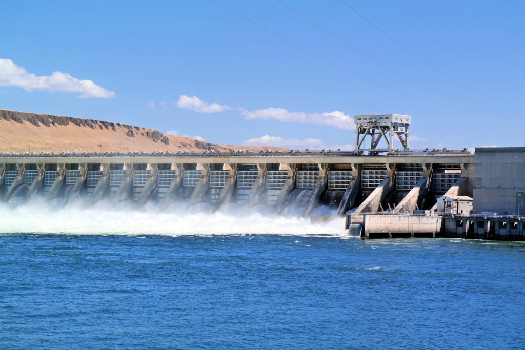
Gavins Point Dam is one of six that drain from ten states and two Canadian Provinces and is causing problems at home with rising ground water and flooding. The upwater dams are bigger and the amount of sediment is what we need – but how to get it here? Can that be done?
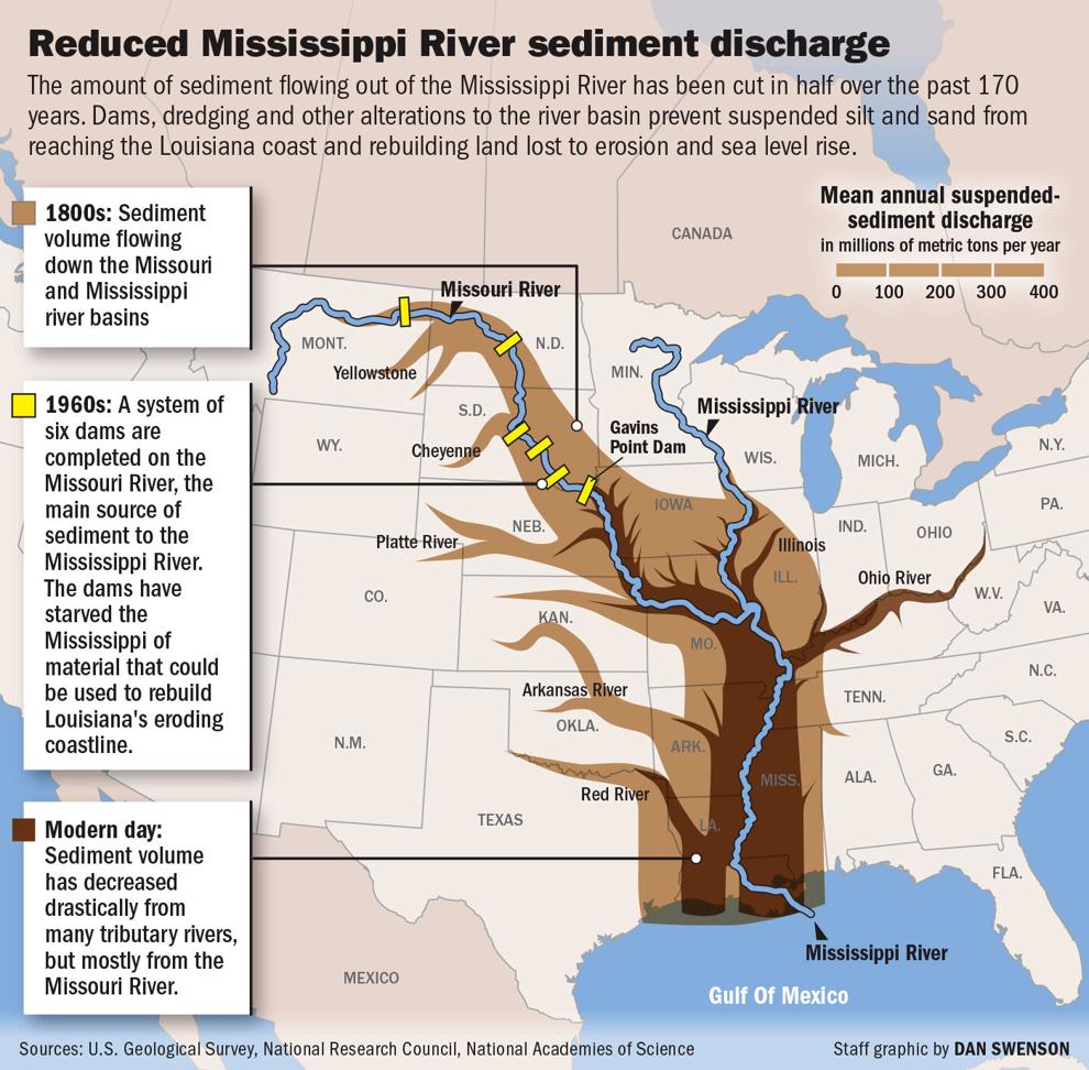
Mapping sediment flows: Graphic depicts how sediment flowing down the Mississippi and Missouri rivers has been cut in half over the past 170 years.
“The Mississippi and the sediment it carries is the lifeblood of Louisiana’s coastal wetlands,” said Bren Haase, executive director of the state Coastal Protection and Restoration Authority. “It’s what built southeast Louisiana over the last 7,000 years.” Before dams, levees, river dredging and other efforts to control the Missouri and Mississippi, more than 440 million tons of sediment found its way to the Louisiana coast each year, according to the U.S. Geological Survey. The latest assessments indicate that only half that much flows through the Mississippi now. Yet sediment, limited as it may be, remains at the core of the state’s 50-year, $50 billion coastal master plan and its flagship project, the Mid-Barataria Sediment Diversion. The $2 billion diversion would funnel mud-laden Mississippi River water through a section of levee on the West Bank of lower Plaquemines Parish and send it spilling into Barataria Bay, potentially rebuilding 28 square miles of marsh.
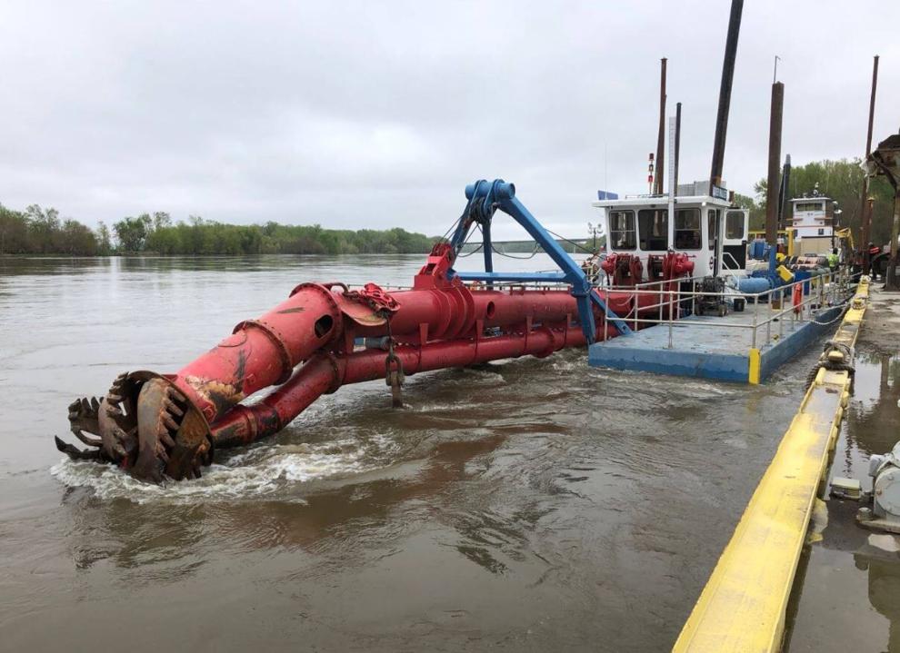
A different way, and one that is not permanent, is dredging up sand and putting in on the barrier islands off the Louisiana coast. This is a short term fix as with rising seas this will have to be redone in about 20 years. A billion dollars have been spent so far and no one knows were the next billion will come from.
“Sediment is the limiting factor in almost all of our restoration plans,” Haase said. “We simply don’t have enough of it.” Along the Missouri, they can’t get rid of it. “Our problem is figuring out what to do with such an immense amount of sediment,” said Sandy Stockholm, executive director of the Missouri Sedimentation Action Coalition, a group that has been working for more than 20 years on the river’s overabundance of sediment. “I really wish we could somehow get it all down to Louisiana, and do it quickly.”
While our wet lands disappear wet lands are forming on the Missouri, especially at Lewis and Clark Lake where the Missouri and the Niobrara Rivers merge. About eight miles of mud flats are forming.
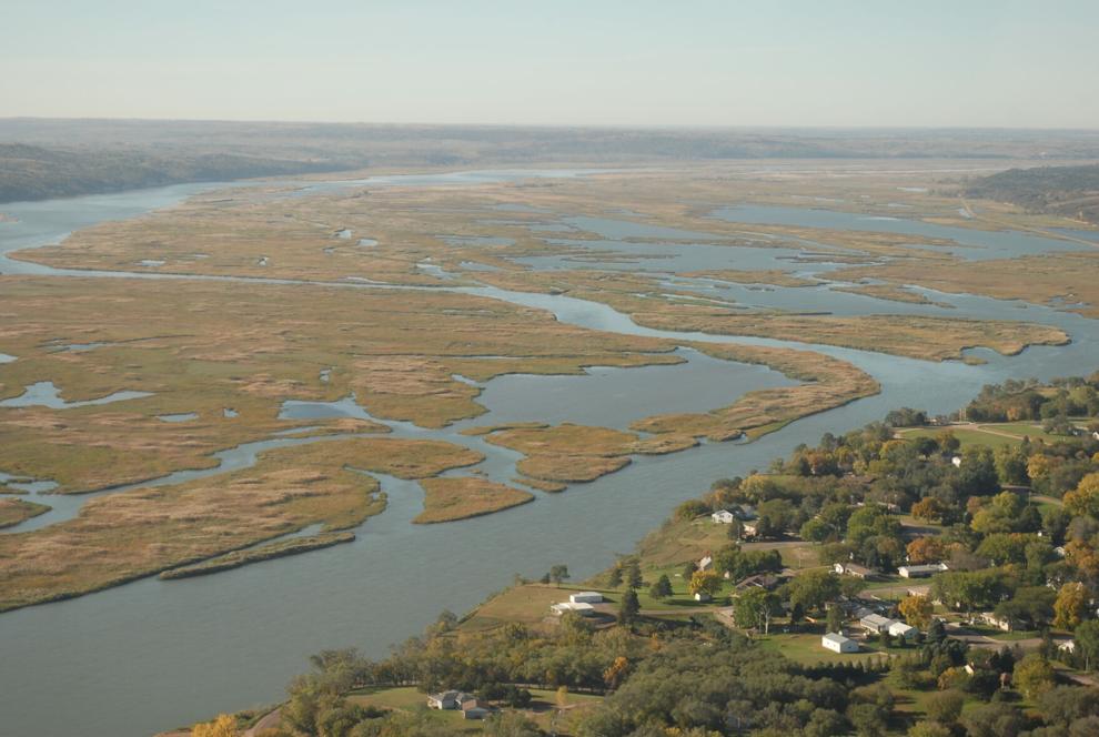
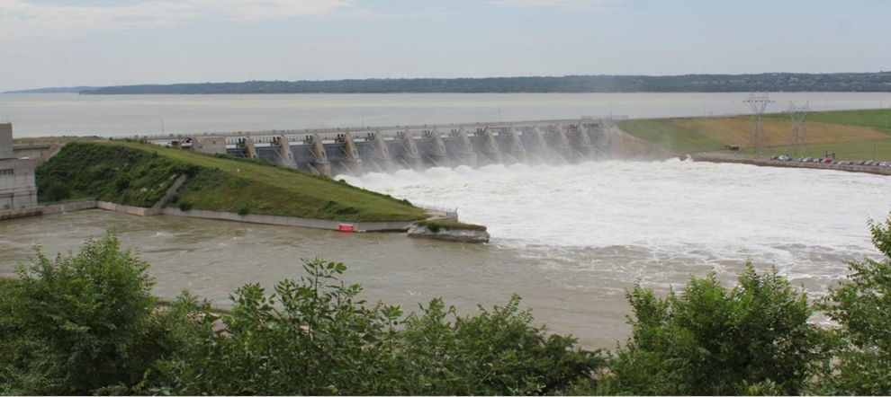
Blocked by the Gavins Point Dam, Missouri River sediment builds up and forms new land in a reservoir between Nebraska and South Dakota. Missouri Sedimentation Action Coalition
Problems started when the dam was being built. Flooding the town so they moved it. But not far enough as in 2019 it flooded again blowing out the dam by ice-filled water.
“The government is offering buyouts, trying to stop groundwater from rising and spending millions of dollars to raise up roads,” Stockholm said. “But these are all Band-Aids. We haven’t been proactive with solutions for the real problem.” Lewis and Clark Lake has already lost more than a third of its water-holding capacity to sediment. In less than 25 years, its capacity will likely be reduced to half. Flood risk will grow, drinking water intakes will clog, popular fishing areas will turn to land and many of the dam’s uses, including hydropower and flood control, will be greatly diminished, Stockholm said.
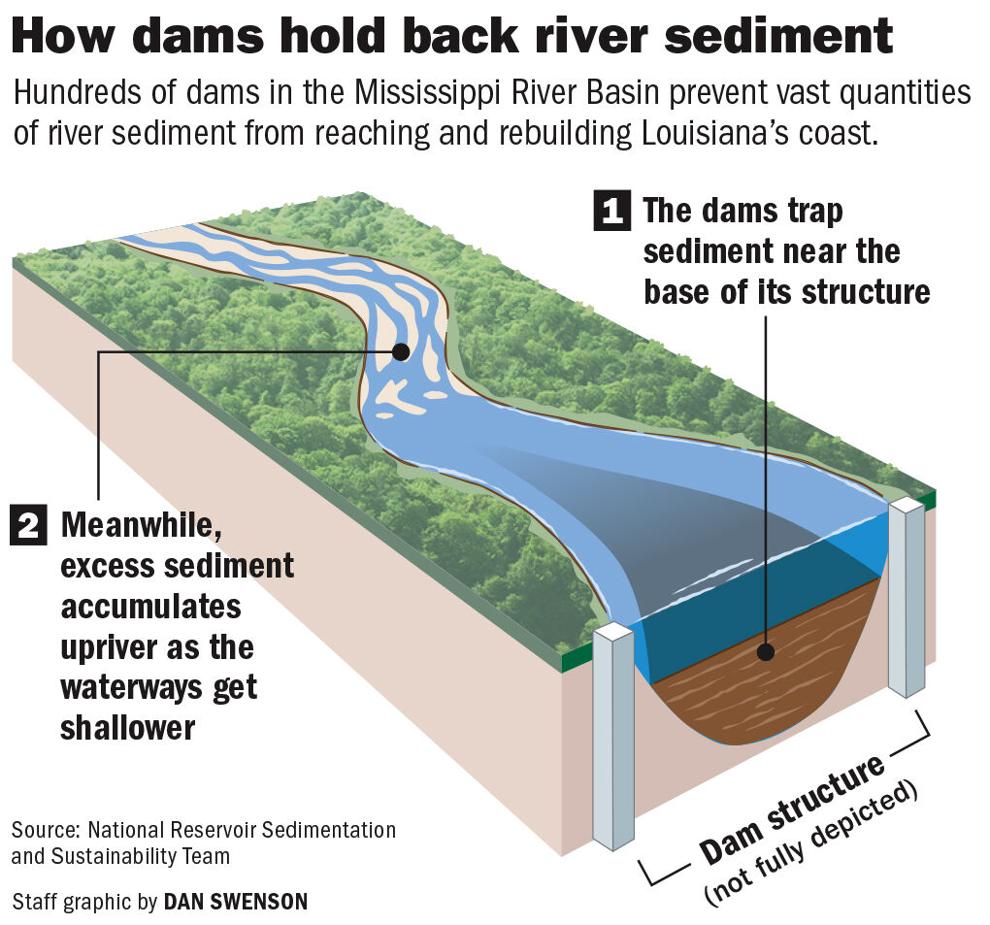
Graphic shows how dams trap sediment that could help rebuild Louisiana wetlands.
Robert Schneiders, author of “Unruly River,” an environmental history of the Missouri, made headlines 20 years ago when he advocated for a seemingly straightforward fix: Tear the dams down. The system’s regulated flows never made the Missouri a busy shipping channel and provided only a tiny fraction of the irrigation envisioned by the dams’ builders. The dams’ hydropower is a positive, he said, but it doesn’t outweigh the negatives, including blocked fish passage and sedimentation, he said. In recent years, increasing flood risk from climate change and short-sighted farming practices have softened Schneiders’ stance on dam removal. Easing the risk means holding on to most of the dams – for now, at least. “Even I am reluctant to encourage removing dams unless there’s significant changes to the watershed,” Schneiders said. He admits there’s little political support for those changes, which would involve moving farms and homes out of floodplains and incentivizing crop rotations that help soil absorb water. But for Schneiders, removing Gavins Point Dam is still a no-brainer. “It’s the least useful structure in the system,” he said.
The Corps of Engineers, however, disagrees. Charged with managing the Missouri River, they still see a need for Gavins Point but do want to rid themselves of the sediment. A National Academy of Science study in 2010 shows there is enough sediment in thee Missouri to boost what Louisiana receives by 20%
.
Why the plan never happened is simple: “It’d cost big dollars and have big impacts,” said Paul Boyd, a Corps reservoir manager. Dredging Lewis and Clark Lake reservoir and piping sediment over the dam isn’t a complicated operation, “but it would be fantastically expensive,” he said. And the costs don’t end there. Not all the sediment would flow to the places that want it, requiring the Corps to clear buildups in shipping channels and along levees the length of the lower Mississippi.
Another factor in the cost is that the Corps has privatized the dredging operations. The Corps has few dredges and the private companies are not large also.
Figuring out what to do with the Missouri’s growing sediment problem is a full-time job for Boyd. “This is certainly a concern from an environmental and sustainability side, and with benefits being lost everywhere,” he said. Yet sediment management has never been a top concern for the Corps or the leaders who fund it. It wasn’t considered in the design of the dams, and it’s not a significant part of the Corps budget. “We haven’t seen any funding to take these actions,” Boyd said. “If Congress directs us to do something [to release sediment], that’s certainly at their discretion.”
chneiders, who now lives in Australia, advises Louisianans to not hold their breath. Midwestern politics has little bandwidth for the Bayou State’s problems. The Upper Mississippi River region has done little to curb the agricultural runoff that’s polluting the Gulf and giving rise to the massive low-oxygen “dead zone.” Why would it take action on sediment? “Honestly, they don’t give a damn about sediment down in Louisiana,” Schneiders said. “People are concerned about their own backyard. They’re not looking downstream.”
Neither the Missouri River activists or those in Louisiana expect the sediment to arrive to help our problems.
Haase, the Louisiana coastal director, isn’t banking on a boost in sediment, but he’d certainly welcome it. The 20% increase in sediment possible under the decade-old Corps plan could supercharge his agency’s land-building prowess by about 3,500 acres per year, according to Haase’s rough estimates. He welcomes that prospect, even though his engineers have cautioned that a big spike in sediment could overload or complicate the operations of Mid-Barataria Sediment Diversion, which is set to run on the Mississippi’s current sediment loads. “More sediment is a good problem to have,” he said. “It could increase our maintenance of the diversion, but I’ll take it.”
Sediment, so near yet so far away. Maybe in the future technology will come up with a solution, but do we have the time to wait?


