
We have oi, we have subsidence and we have levees and a new report say this is causing land loss, which we also have.
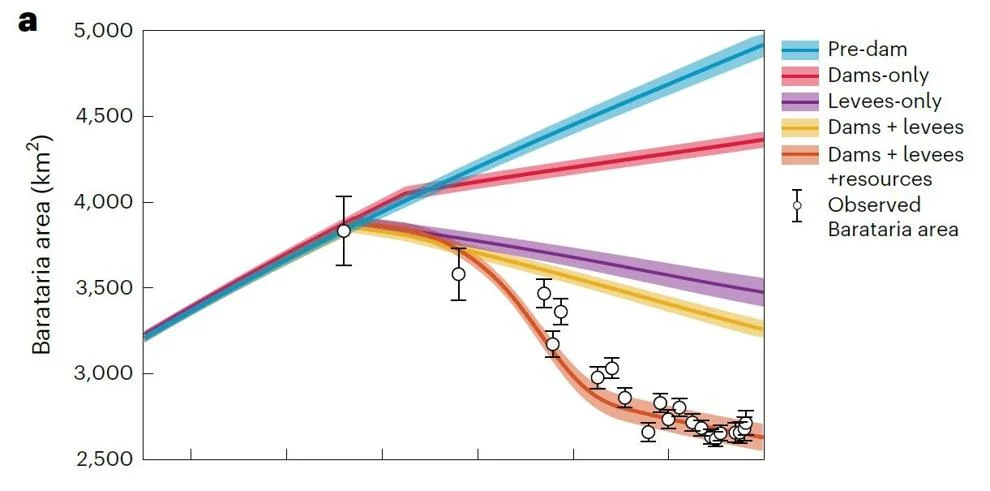
A new study of the dramatic loss of wetlands in the Barataria Basin south of New Orleans during the last 130 years concludes that the two main causes have been construction of levees along the Mississippi River and subsidence due to oil and gas activity. But the study also contains potential good news: There may be enough sediment in the river to rebuild coastal land, disputing earlier estimates. The peer-reviewed study was published Monday in the scientific journal Nature Sustainability. Co-authors include scientists with Indiana University, LSU and the Moffatt and Nichol infrastructure advisory firm. “The question that I’m really interested in is how well do we understand why that land loss is occurring, and do we know enough to actually make a reasonably accurate prediction that matches that land loss curve,” said lead author Douglas Edmonds, associate professor of geology at Indiana University. Co-authors included LSU coastal sustainability Prof. Robert Twilley and LSU geology Prof. Samuel Bentley.
nola.com
U.S. Geological Survey study. (Nature Sustainability)
The Barataria Basin is south of us and is part of the Mississippi Delta.
The Barataria Basin includes land south of New Orleans between the east bank of Bayou Lafourche and the west bank of the Mississippi River. It is part of the Mississippi River Delta, formed over the past 7,000 years through sediment deposition from the river, a process now blocked by flood-prevention levees. The flow of water and sediment from the Mississippi into Bayou Lafourche and the basin was also blocked off by a dam in 1903. A key part of the study is its conclusion that the rapid development of oil and gas exploration and production in the Barataria Basin tracks the accelerated increase in land loss that began in about 1930 and peaked in 1978. As oil and gas development – and the pumping of oil, gas and the water accompanying it – dramatically dropped between then and 1990, the reduction in land loss mirrored it.

(Nature Sustainability)
A study in 2017 documented the land loss.
The rapid changes in the rate of land loss were documented in a 2017 study led by U.S. Geological Survey geographer Brady Couvillion, which concluded the state’s coastline lost an estimated football field every 34 minutes in 1978. That rate slowed to a football field every 100 minutes by 2016. Some of the slowing is also linked to construction of federal, state and local wetland restoration projects. Edmonds said the fluid extraction resulted in increased rates of deep subsidence, where water and other fluids withdrawn from underground sediment or rock reduced pressure, allowing layers above it to sink, even causing geological faulting in some cases, until oil and gas production in the basin slowed. The study points to 2005 research by USGS geologist Robert Morton that found subsidence caused by wells in the basin extended to between 3 and 6 miles from each wellfield. There are 125 wellfields, spaced about 5 miles apart – containing about 26,600 individual wells – in the basin. But oil and gas development also included construction of well service and navigation canals at the surface, which directly removed soil, but also increased shallow subsidence through the weight of sediment berms stacked along canal edges, and the disruption of wetland hydrology, Edmonds said.

(Nature Sustainability)
Another study puts the oil and gas front and center for the damages to the land.
A study by the late University of New Orleans geologist Shea Penland in 1996 for the USGS and the Gas Research Institute concluded that about 36 percent of the wetland loss in southeastern Louisiana between 1932 and 1990 was the result of the direct and indirect effects of actions taken by the oil and gas industry. Edmonds said additional research is needed to better understand the relative roles of both surface disturbance by canals and the effects of oil and gas wells. But he said it is clear the present land loss rate is significantly less than at the height of oil and gas production in the basin, and is likely to continue to be lower. “If our model is correct, and resource extraction really caused this fast period of land loss, now that resource extraction has declined significantly, the rate of land loss into the future may be much less than it has historically been,” Edmonds said. Torbjörn Törnqvist, a Tulane University geology professor and expert in deep subsidence, said the new study does a good job of addressing the role of oil and gas in land loss in the basin, but he also has questions about the role of canals. “My take would be that wave erosion is the elephant in the room, more than the spoil banks,” Törnqvist said before referencing the now-closed Mississippi River-Gulf Outlet shipping channel. “Just think about how much widening has happened along MRGO after it was first dug.”

(Nature Sustainability)
The study said these results could also be put to the Terrebonne Basin.
The study pointed out that its findings may also apply to the Terrebonne Basin, which lies between the east side of the Atchafalaya Basin floodway and the west bank of Bayou Lafourche. Combined, the two basins represent 50% of land loss in the Mississippi delta. The study also delved into the question of whether there is sufficient sediment remaining in the lower river to rebuild much of the coast. The construction of dozens of dams within the river basin north of Louisiana, combined with modern farming practices, has dramatically reduced the amount of sediment available since 1890. However, the study found the river still carries enough sediment to build land quickly enough to offset present rates of sea level rise, if it can be moved into the basin. That disputes 2009 findings by LSU geologists Michael Blum and Harry Roberts that warned that Louisiana’s coastline would lose more than 4,000 square miles of coastline by 2100 because the Mississippi and Atchafalaya rivers carry only half the sediment they did a century ago. Blum is now at the University of Kansas.
The question for the river is not how much sediment it carries but how much it leaves.
The new study says the most important factor for land building is not how much sediment remains, but how much leaves the river and ends up building land. “I’m not saying the river is sediment rich, but it just may not be as sediment starved as we commonly thought,” Edmonds said. “And it may be that some carefully planned diversions might actually be able to really create a return on investment, and that creates a positive outlook for the effectiveness of diversions.” The study said the planned $2.3 billion Mid-Barataria Sediment Diversion “may be ideally timed because any newly constructed land may be more sustainable than previously thought.” It said the projected 21 square miles of new land built by that diversion over 50 years “could be exceeded, thereby further reducing the impacts of storm surge on local infrastructure and resulting in a more sustainable coast.” However, in an interview, Edmonds said his team of researchers did not simulate the land-building potential of that or any other diversion proposal.
Good news after bad but it shows the damage of oil and gas.


