La Nina is now longer until the next time but that may help us.
Hurricane-weary Louisianans will shed no tears over this farewell. The National Weather Service’s Climate Prediction Center announced Thursday that the La Niña weather pattern, which lasted three years and produced conditions favorable to the formation of hurricanes, has finally come to an end. La Niña can help hurricanes form because it results in less wind shear in the Atlantic. Wind shear can help break apart storms instead of allowing them to strengthen. La Niña usually lasts for only a year or two before transitioning into El Niño, which is less favorable to hurricane formation. However, La Niña conditions have persisted since around August 2020, with a couple months of neutral conditions in early summer of 2021. Climatologists count it as three years old because it lasted for three winters. In that time, Louisiana was hit by a gauntlet of storms, most notably Hurricane Laura, which made landfall in the state’s southwest in late August of 2020 and caused about $17.5 billion in damage, and Hurricane Ida, which hit the southeast in 2021 and left behind some $55 billion in damage. The last time La Niña lasted more than three years was from 1973 to 1976. The only other time such an extended La Niña was recorded was from 1954 to 1956.
nola.com
We are now in a neutral system with nothing either encouraging or discouraging hurricanes.
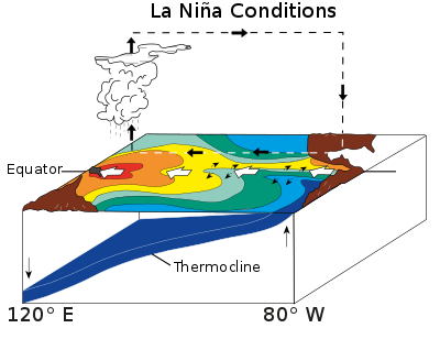
With La Niña departing, conditions are now considered neutral for what is known as the El Niño-Southern Oscillation, or ENSO, cycle. Meteorologists say the arrival time for the El Niño pattern is still unknown. “The forecaster consensus is indeed very confident that neutral conditions will remain through the spring,” Emily Becker of the University of Miami’s Cooperative Institute for Marine and Atmospheric Studies wrote on the climate center’s website. La Niña is a set of weather conditions that pushes warm water away from the U.S. towards Asia, causing lots of cold water to move to the ocean’s surface. On the flip side is El Niño, which generally has the opposite effect and results in the central and eastern Pacific having warmer waters.
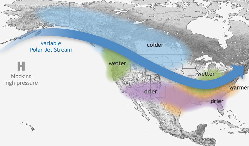
image via the National Oceanic and Atmospheric Association
The Jet Stream is the medium used by weather patterns
ENSO cycles influence the jet streams, where cold air meets hot in the atmosphere. Because La Niña pushes the jet stream and the wet air it carries in further north, the southern Atlantic is left with drier air and sometimes drought conditions. However, there’s also less wind shear where hurricanes develop in the Atlantic that can reduce hurricanes’ energy. El Niño usually results in fewer hurricanes. When the jet stream flows closer to the south, the wet air can cause heavier rain and floods. And the wind shear from the jet stream makes it harder for strong tropical storms to develop. “The lack of El Niño or La Niña means that there is no seasonal-scale influence from the Pacific to push around the global atmospheric circulation and influence seasonal climate patterns,” wrote Becker.

image via the National Oceanic and Atmospheric Association
El Nino is not expected to form until the summer.
Forecasters predict that El Niño won’t begin until late summer at the earliest, though they say it’s still too early to tell how soon. “Right now is a very tricky time of year for the models, due to the ‘spring predictability barrier,'” wrote Becker. “ENSO events peak in the winter and tend to decay and transition in the spring, so models often don’t have a lot of strong signals to go on.”
No time to sit up and put your feet on the railing as it does not mean no hurricanes!

