
NOAA GOES-EAST SATELLITE IMAGE
The warm Atlantic waters have raised the number of storms expected.
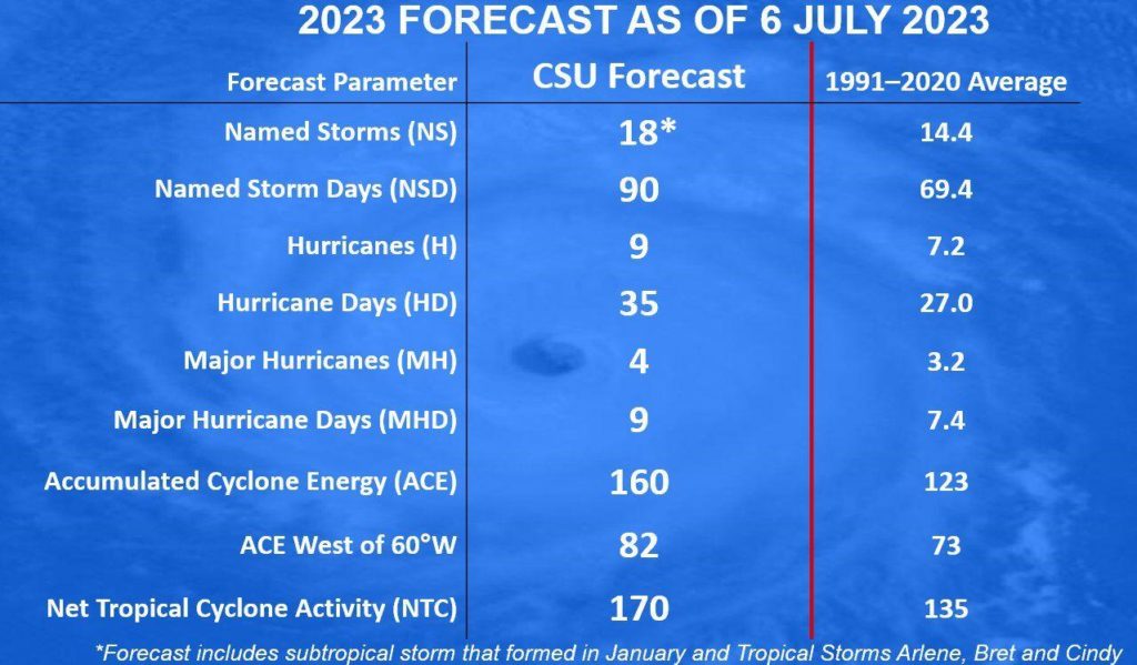
Unusually warm waters in the Atlantic Ocean will likely cause more tropical storms and hurricanes than previously forecast this year, Colorado State University climatologists said Thursday. Five weeks into hurricane season, they predicted an above-average year with 18 named storms, nine of those hurricanes and four of them major hurricanes of Category 3 or greater intensity with top winds faster than 111 mph. “The probability of U.S. major hurricane landfall is estimated to be above the long-period average,” the revised forecast said.
nola.com
Initially there were fewer storms expected but they did not count on the warm water.
The first forecast from the university’s Tropical Weather and Climate Research Group, issued in April, foresaw a slightly below average season: 13 named storms, six hurricanes and two major hurricanes. In late May, the National Oceanic and Atmospheric Administration predicted 12 to 17 named storms, near average. But in June alone, the first month of hurricane season, there were three named storms, none of them hurricanes. And in May, the federal agency said it had belatedly identified an unnamed subtropical storm that formed Jan. 16-17 in the Atlantic. Hurricane season lasts through Nov. 30. “As is the case with all hurricane seasons, coastal residents are reminded that it only takes one hurricane making landfall to make it an active season for them,” Colorado State said. “They should prepare the same for every season, regardless of how much activity is predicted.” Over the past nine years, Colorado State says its June forecasts have been 64% accurate.

COLORADO STATE UNIVERSITY IMAGE
Every year we add to the data used in these projections.
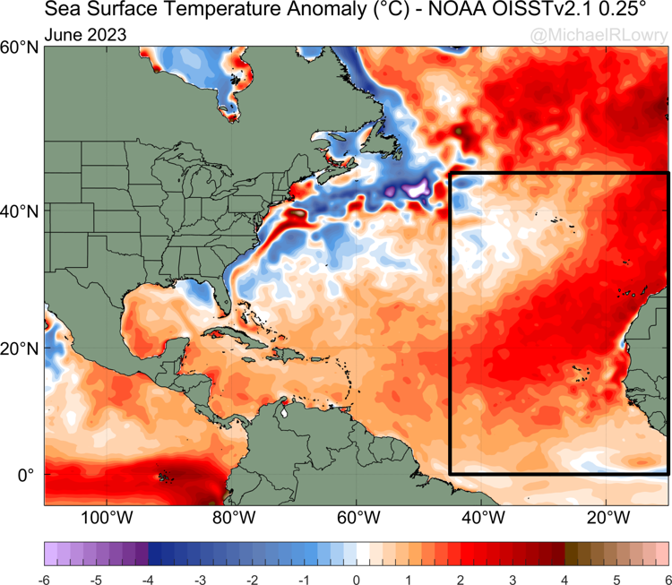
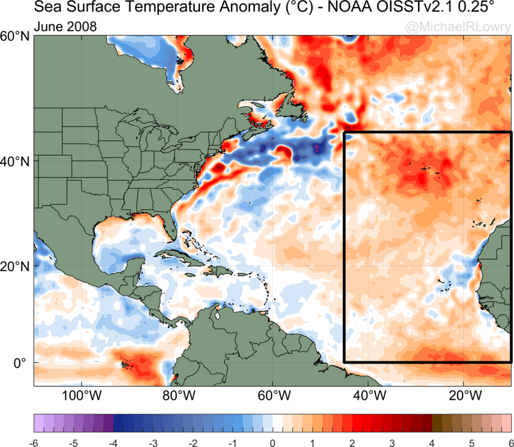
The university’s revised forecast is based on models that use as many as 40 years of data points. Among them: Atlantic sea surface temperatures, sea level pressure and the change in wind direction and speed in the atmosphere, or vertical wind shear levels. Its meteorologists said the increase in expected storms is due to a dramatic warming of the Atlantic’s surface temperatures, especially in areas where tropical systems typically form. The warming of Atlantic waters reached a record high in June. According to National Oceanic and Atmospheric Administration data since 1979, surface temperatures in the Atlantic last month were about 3 degrees warmer than normal. The previous record was in 2008: 1 to 2 degrees above normal. The current warming is being called an Atlantic Niño or Dakar Niño by some climate scientists. The relatively new phenomenon has been recorded only a handful of times. The previous Colorado State and federal forecasts took into account that the Atlantic was warmer than normal, which can give more fuel for hurricanes to gain energy.
Warmer water was anticipated due to El Nino.
However, they also expected that the return of a Pacific El Niño, a weather phenomenon that makes the Pacific Ocean warmer than normal, would result in increases in upper wind shear in portions of the Atlantic where tropical systems are born. That would disrupt tropical disturbances in the Atlantic. The Pacific El Niño conditions are still likely to increase into the fall, the federal agency says, but Colorado State forecasters think their wind shear in the Atlantic will not outweigh the effects of the warmer Atlantic water. “While we continue to anticipate a robust El Niño for the peak of the Atlantic hurricane season, most of the tropical and subtropical Atlantic now has record warm sea surface temperatures,” the Colorado State revised forecast said. “The extreme anomalous warmth in the tropical and subtropical Atlantic may counteract some of the typical El Niño-driven increase in vertical wind shear.”
The Colorado reports differ from what NOAA puts out.
Colorado State has released hurricane season forecasts since 1984. Its forecast differs from the National Oceanic and Atmospheric Administration’s seasonal forecast, which provides broader estimates of the number of storms that might form each season. The university’s pre-season forecast also includes predictions on chances of storm landfalls along the U.S. coastline, which the federal agency forecast does not include. The federal agency’s next and final seasonal forecast comes in early August, in advance of the Sept. 10 average peak of the season. Colorado State’s next forecast and final forecast will be Aug. 3.
So, more storms and if they hold off until the 5th of August for me!


