You think it has rained? It has and twice as much as normal.
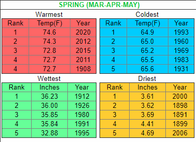
The amount of precipitation since Jan. 1 has reached 41½ inches, almost double the average year-to-date amount of less than 22¼ inches. And National Weather Service forecaster Shawn O’Neil said this season has moved into the Top 5 wettest New Orleans springs since data collection began in 1871. The Weather Service considers the spring to run from March through May. Spring in New Orleans isn’t even over yet, and precipitation amounts have reached almost 34⅔ inches since March, more than double the average of less than 13 inches. “It’s a significantly high number,” O’Neil said. To blame: The quantity of moisture with tropical characteristics coming from the Gulf of Mexico. When that extreme amount of water vapor coming from warm surface waters pulls ashore, it increases humidity and mixes with other processes that make for an efficient, powerful rainstorm. “The moisture is the fuel to the fire,” O’Neil said. “We’ve got a lot of fuel right now.”
nola.com
Forecasters are seeing more storms that can drop 3-5 inches an hour rain.
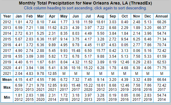
South Louisiana is no stranger to these storms. We see them frequently and some time flooding occurs. Last year with the number of hurricanes that hit us, we only had 31.66 inches of rain and this spring has eclipsed that.
There are certainly more disadvantages to these frequent downpours than benefits, O’Neil said, like oversaturated ground that increases the risk of flash and river flooding. Forecasters on Monday issued several flash flood watches and warnings, with some parishes still under the former, as an intense patch of storms moved from Lake Charles to Baton Rouge. Street flooding was also a major issue this week, bringing several communities to a halt as several feet of water closed roads and moved into homes. Another thing these storms can oversaturate: trees. O’Neil said forecasters are seeing 30 mph winds blow through and topple trees, weakened from the previous bout of rain, onto power lines and buildings.
If we have a hurricane season less than last year, every increase of rain causes these symptoms. We know this will be a heavy year nationwide and the first two tracked storms have already appeared – before hurricane season begins.
“For residents, it’s always a good thing to stress that they have a plan in place for hurricane season,” O’Neil said. “Any slow-moving storm coming here is a concern, especially after the spring we’ve had.”
So we are warned and thus we can make preparations for us, but not for the saturated ground.


