The storms are coming and this is the schedule for us. This is a second one on the storms from nola.com.
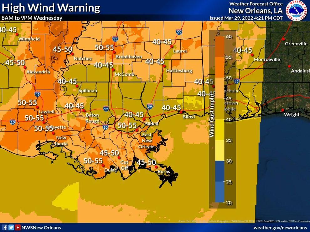
A week after a powerful tornado tore through the New Orleans area, southeast Louisiana could see more damaging winds and possibly tornadoes Wednesday afternoon, National Weather Service forecasters said. Wind advisories are in effect. A low-pressure system is expected to move through the New Orleans and Baton Rouge areas, packing wind gusts of more than 70 mph, comparable to winds associated with a Category 1 hurricane on the Saffir-Simpson scale. Embedded tornadoes and tornadoes strong enough to tear roofs from homes are also possible, though damaging winds are the bigger threat, forecasters said. Baton Rouge is more at risk for severe weather than is New Orleans. “We could see wind gusts in excess of 70 mph, which are certainly just as capable of producing damage as some tornadoes,” said Bob Wagner, a meteorologist with the Weather Service’s Slidell office.
nola.com
Use common sense and take normal precautions. I have brought my trash cans in.
Residents should avoid elevated roadways and secure garbage cans and lawn furniture ahead of the system’s arrival, Wagner said. The window for severe weather in the Baton Rouge and New Orleans areas is between Wednesday at 7 a.m. and Thursday at 7 a.m. Severe storms are likeliest between 3 p.m. and 7 p.m. in the Baton Rouge area, and between 4 p.m. and 10 p.m. in most of the New Orleans area. Slidell and Boothville will see storms between 9 p.m. and 1 a.m.
It comes to us after Baton Rouge, around 4-5 and then be gone by midnight.
Severe storms are likeliest between 3 p.m. and 7 p.m. in the Baton Rouge area, and between 4 p.m. and 10 p.m. in most of the New Orleans area. Slidell and Boothville will see storms between 9 p.m. and 1 a.m. NWS New Orleans (@NWSNewOrleans) March 29, 2022 Before the storms arrive, areas in their path will see sustained winds of 25 to 35 mph, with some gusts of 50 mph, forecasters said. One to two inches of rain are also expected, though higher amounts are possible in some locations. Hail could also form. Any tornadoes that form are expected to notch an EF2 or greater on the Enhanced Fujita scale, with winds between 113 and 157 mph. That’s strong enough to tear off roofs, demolish mobile homes and uproot large trees. The severe weather event comes eight days after a tornado packing winds of 160 mph slammed into Arabi, destroying dozens of homes and businesses. The EF3 tornado also wreaked havoc in Terrytown, Gretna and New Orleans East, according to surveyors. To prepare for Wednesday, the Weather Service encourages residents to sign up for severe weather warnings and have a safe place to take shelter.
Be safe, stay safe and be careful.


