
Hurricane forecasters on Tuesday, Sept. 20, 2022, were tracking Hurricane Fiona and two disturbances in the Atlantic.
(Image via National Hurricane Center)
Fiona is heading north but there is another system hugging South America.
A tropical depression formed in the Atlantic early Tuesday, and another one could form later this week in the Caribbean, hurricane forecasters said. They are also tracking powerful Hurricane Fiona, which is strengthening in the Atlantic after causing catastrophic flooding in Puerto Rico and the Dominican Republic. Hurricane Fiona and the Atlantic depression don’t pose a threat to Louisiana. It’s too early to accurately say where the Caribbean disturbance could go if it develops. The next available names are Gaston and Hermine if anything strengthens into tropical storms this week. Here’s what we know about the tropics as of 7 a.m. Tuesday from the National Hurricane Center.
nola.com
Hurricane Fiona in the Bahamas
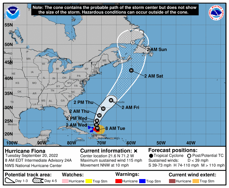
Hurricane Fiona was strengthening in the Atlantic early Tuesday and bringing hurricane conditions to the Turks and Caicos. The storm caused catastrophic flooding in Puerto Rico and the Dominican Republic and claimed a life in the French territory of Guadeloupe. As of 7 a.m., the center of Fiona was about 10 miles northwest of Grand Turk Island and was moving northwest at 10 mph. It has winds of 115 mph, which means it is a Category 3 hurricane. It’s expected to continuing strengthening the next few days, with peak winds of 125 mph. Flooding continues across Puerto Rico, where forecasters said 35 inches of rain could fall, leading to life-threatening flooding, mudslides and landslides. President Joe Biden has declared a state of emergency.
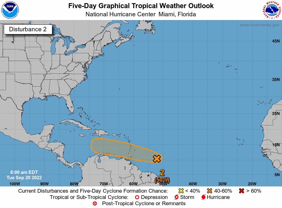
Disturbance heads toward Caribbean
Forecasters also are tracking a tropical wave that’s several hundred miles east of the Windward Islands and is producing disorganized showers and thunderstorms. It’s moving west at 15 to 20 mph and is expected to reach the Caribbean Sea, forecasters said. Some gradual development of the system, forecasters said, and a tropical depression could form late this week as it moves into the Caribbean. It has a 50% chance of developing into at least a tropical depression within five days. The shaded area on the graphic is where a storm could develop and is not a track. The National Hurricane Center releases a track when a tropical depression forms or is about to form. The categories, in order of increasing strength, are tropical depression, tropical storm and hurricane (categories 1 through 5). Systems are named when they develop into a tropical storm.
Depression in the Atlantic
A tropical depression formed in the Atlantic early Tuesday, forecasters said. It does not pose any immediate threat to land. It’s about 950 miles southwest of the Azores and was moving north over the open waters of the Atlantic, forecasters said. They are expected to release a track at 10 a.m.
We have seen an increase in the disturbances this week and so it is picking up. Most have been in the Atlantic endangering all the ships at sea. But the one heading into the Caribbean may give us problems or more likely Texas.


