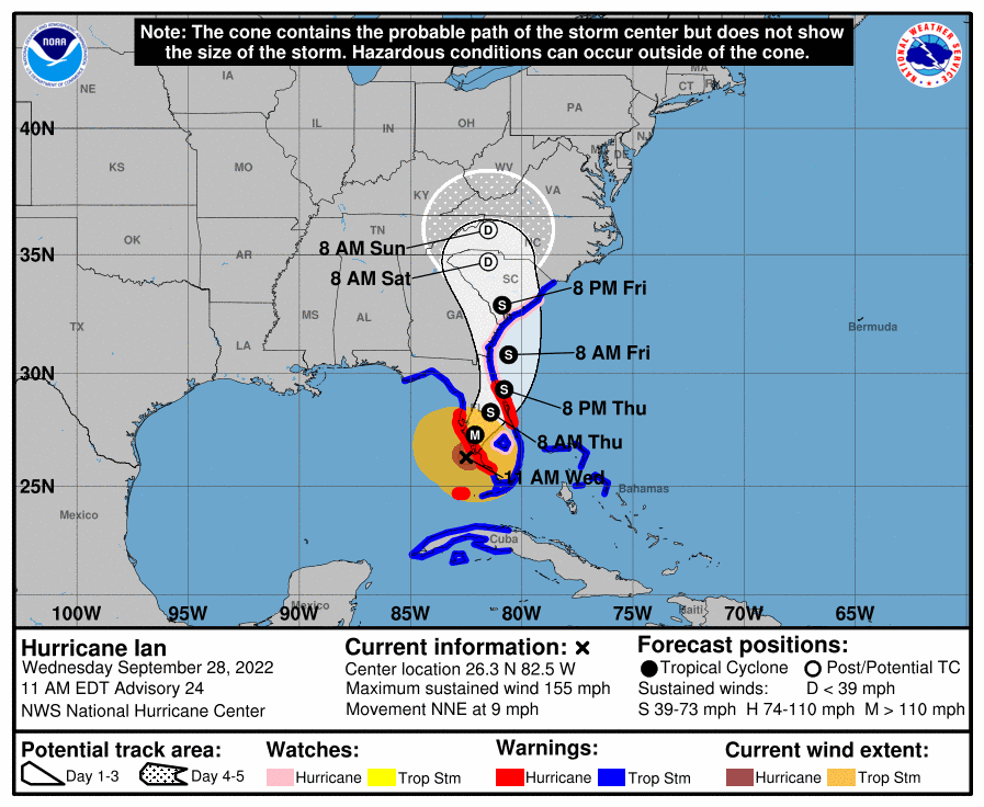
Hurricane Ian is ashore coming there near Fort Walton Beach so south of Tampa sparing them a direct hit.
Ian’s center was about 45 miles northwest of Naples at 10 a.m. Wednesday, as it churned toward toward the coast at 9 mph. Ian’s plodding pace meant the storm was expected to spend a day or more crawling across the Florida peninsula, dumping flooding rains of 12 to 24 inches across a broad area including Tampa, Orlando and Jacksonville in the state’s northeast corner. Catastrophic storm surges could push 12 to 18 feet of water across more than 250 miles of coastline, from Bonita Beach to Englewood, the hurricane center warned. “It’s going to get a lot worse very quickly. So please hunker down,” DeSantis said. More than 2.5 million people were under mandatory evacuation orders, but by law no one could be forced to flee. The governor said the state has 30,000 linemen, urban search and rescue teams and 7,000 National Guard troops from Florida and elsewhere ready to help once the weather clears.
nola.com
The typical pre-landing rush to prepare.
Florida residents rushed ahead of the impact to board up their homes, stash precious belongings on upper floors and join long lines of cars leaving the shore. Some chose to stay and ride out the storm. Jared Lewis, a Tampa delivery driver, said his home has withstood hurricanes in the past, though not as powerful as Ian. “It is kind of scary, makes you a bit anxious,” Lewis said. “After the last year of not having any, now you go to a Category 4 or 5. We are more used to the 2s and 3s.” Forecasters predicted Ian would make landfall more than 100 miles south of Tampa and St. Petersberg, likely sparing the densely populated Tampa Bay area what would have been its first direct hit by a major hurricane since 1921. Officials warned Tampa residents that they still faced threats from powerful winds and up to 20 inches of rain. “Please, please, please be aware that we are not out of danger yet,” Tampa Mayor Jane Castor said in a video on Twitter. “Flooding is still going to occur.”

The storm grew overnight.
During the night, Ian went through a natural cycle when it lost its old eye and formed a new one. The timing was bad for the Florida coast, because the storm got stronger and larger — 120 mph to 155 mph — with landfall just a few hours away. The size of the storm also grew, with tropical storm force winds extending 175 miles from the hurricane’s center. “With the higher intensity you’re going to see more extensive wind damage,” University of Miami hurricane researcher Brian McNoldy said. “The larger wind field means that more people will experience those storm-force winds.” The most damaging winds could hit a coastline where the population has jumped sevenfold since 1970, according to the U.S. Census. Authorities worried that many residents would ignore orders to evacuate.
Evacuate
Vinod Nair wasn’t taking any chances. He drove inland from the Tampa area Tuesday with his wife, son, dog and two kittens to a hotel in Orlando, where only tropical storm force winds were expected. “You can’t do anything about natural disasters,” Nair said. “We live in a high-risk zone, so we thought it best to evacuate.” Ash Dugney warily watched ocean water being sucked out below a Tampa Bay pier Wednesday morning. He said he didn’t trust Tampa’s storm drainage system to keep his corner tuxedo rental business safe from flooding that he said happened in his neighborhood even during mild storms. “I don’t care about the wind and the rain and the stuff like that, I just care about the flooding,” Dugney said, adding that he moved essentials out of the shop and moved other items up to above waist-high level.
Flooding and flash flooding is expected.
Flash floods were possible across all of Florida. Hazards include the polluted leftovers of Florida’s phosphate fertilizer mining industry, more than 1 billion tons of slightly radioactive waste contained in enormous ponds that could overflow in heavy rains. Parts of Florida’s east coast faced a storm surge threat as well, and isolated tornadoes were spinning off the storm well ahead of landfall. One tornado damaged small planes and a hangar at the North Perry Airport, west of Hollywood along the Atlantic coast. More than 190,000 homes and businesses were without electricity before landfall Wednesday, and Florida Power and Light warned those in Ian’s path to brace for days without power. Walt Disney World and Sea World in Orlando are closed Wednesday and Thursday, along with Busch Gardens in Tampa. Airports in Tampa, St. Petersburg and Key West are closed as well. Parts of Georgia and South Carolina could see flooding rains and some coastal surge into Saturday. Georgia Gov. Brian Kemp preemptively declared an emergency, ordering 500 National Guard troops onto standby to respond as needed. Before turning toward Florida, Ian battered Cuba and brought down the country’s electrical grid, blacking out the entire island. It also caused destruction in Cuba’s world-famous tobacco belt. No deaths were reported.
I posted the story on how there are similarities between us and Tampa and much in this story reflects that thought.


