
Hurricane forecasters on Thursday, Oct. 6, 2022, were tracking two systems in the Caribbean and Atlantic.
(Image via National Hurricane Center)
Activity continues in the near Caribbean as the disturbance heads to Honduras and Nicaragua. The one in the Atlantic is staying there.
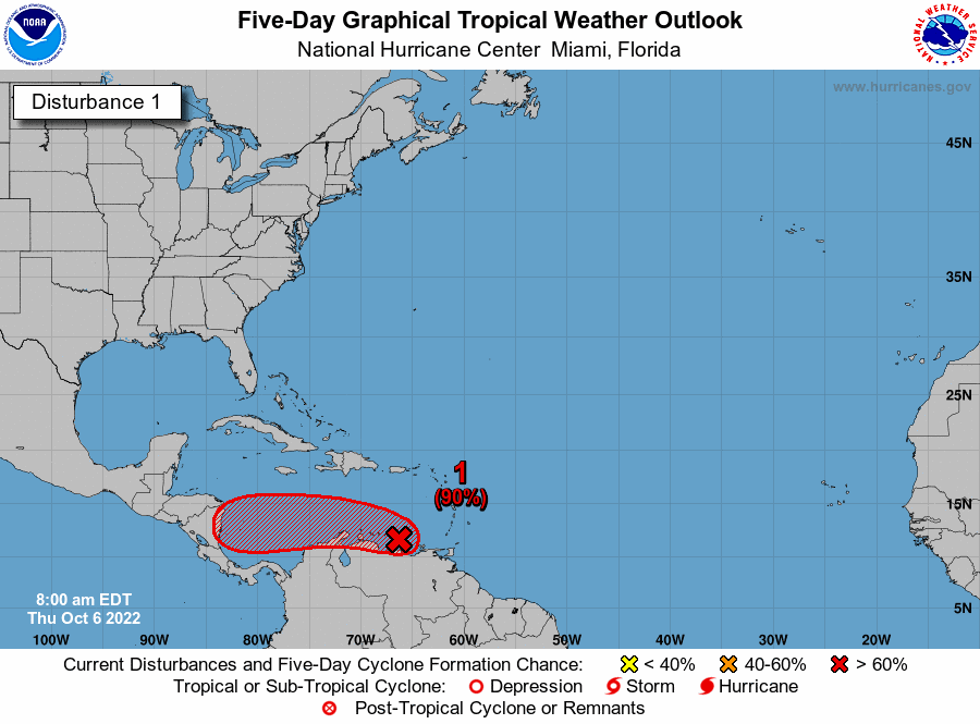
A tropical depression is likely to form in the next day or two in the Caribbean, hurricane forecasters said Thursday. The early forecasts from the National Hurricane Center show the system, currently called Invest 91L, heading for Nicaragua and Honduras. If it strengthens into a tropical storm, the next available name is Julia. Meanwhile, a tropical depression in the Atlantic is expected to begin weakening soon. It doesn’t pose a threat to land. Here’s the latest from the National Hurricane Center as of 7 a.m. Thursday.
nola.com
Strengthening expected
A disturbance in the Caribbean Sea is likely to develop into a tropical depression in the next day or two, forecasters said. As of 7 a.m., the low pressure system was over the southeast Caribbean just off the coast of Venezuela. It was producing “an expansive area” of showers and thunderstorms over the Windward Islands and parts of South American. It’s expected to interact with land along the northern coast of South America, which could hinder “significant development,” forecasters said. However, the system is moving west at 15 mph and development conditions are more favorable once it moves back over the water. It has an 80% chance of developing into a tropical depression within 48 hours. Additional strengthening is expected while the system moves west toward Central America late Friday through Sunday, forecasters said. Regardless of development, heavy rainfall and gusty winds are possible over portions of the Windward Islands, the ABC Islands and portions of South America. The shaded area on the graphic is where a storm could develop and is not a track. The National Hurricane Center releases a track when a tropical depression forms or is about to form.

Depression in Atlantic
A tropical depression in the Atlantic is expected to begin weakening soon and become a remnant low in the next day, forecasters said. As of 4 a.m., the depression was about 635 miles northwest of the Cabo Verde Islands and was moving northwest at 13 mph. It has winds of 35 mph. No watches or warnings are in effect related to the storm.
We continue in a lull which does not bother me.


