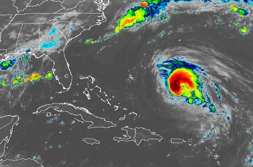
(Satellite image via NOAA)
Thjis is the Wednesday update and I waited until now to see if the morning one was updated.
Hurricane Earl formed in the Atlantic early Wednesday and is predicted to strengthen into a Category 3 storm, hurricane forecasters said. It is expected to stay in the Atlantic and head toward Bermuda, where a tropical storm warning has been issued for residents. It doesn’t pose threat to Louisiana. Earl is the second hurricane of the Atlantic season. Hurricane Danielle formed last week after a two-month lull in the tropics. No named storms formed in August, which is only the third time that’s happened since 1950.
nola.com
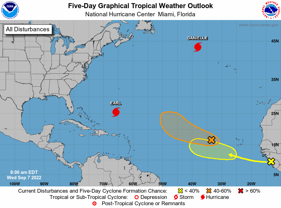
image via National Hurricane Center
There ate still 4 systems in the Atlantic with one that might come into the Gulf.
Earl is one of four systems forecasters are tracking in the Atlantic. Meanwhile, the Caribbean Sea and the Gulf of Mexico are expected to stay quiet for the next 48 hours, forecasters said. Here’s what to know about the tropics as of 7 a.m. Wednesday from the National Hurricane Center.
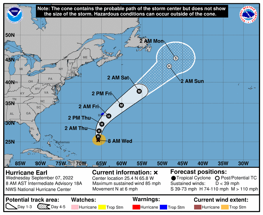
Hurricane Earl
Hurricane Earl continued to strengthen Wednesday and had winds of 85 mph as of 7 a.m., forecasters said. Strengthening is expected for the next couple of days. Peak winds of 125 mph are forecast, which would make it a powerful Category 3 hurricane. Category 4 storms have winds of at least 130 mph. As of 7 a.m., Earl was about 485 miles south of Bermuda and was moving north at 6 mph. On the forecast track, the center of Earl is expected to pass to the southeast of Bermuda late Thursday. Tropical storm conditions are expected to begin Thursday afternoon in Bermuda, along with life-threatening surf and rip current conditions.
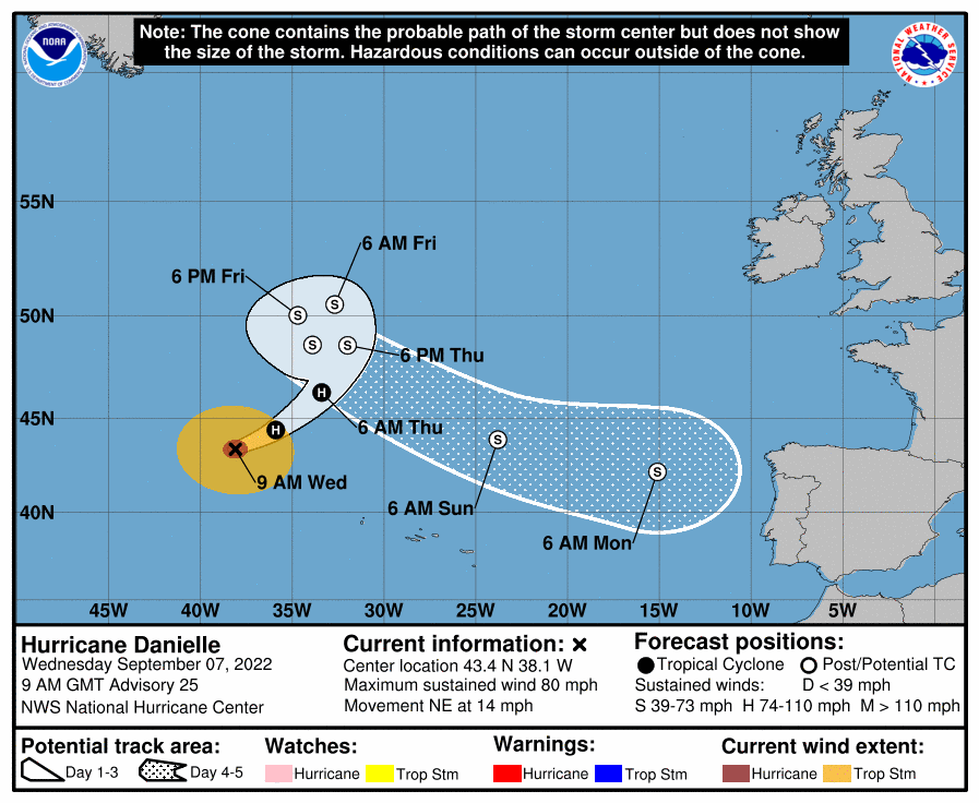
Hurricane Danielle strengthens.
Hurricane Danielle is in the open Atlantic, but is expected to turn and could eventually reach Portugal and Spain as a tropical storm, according to the National Hurricane Center. As of 4 a.m., Danielle was about 690 miles northwest of the Azores. The storm is expected to stay over the open Atlantic during the next couple days, forecasters said. It strengthened a little overnight while picking up speed. It’s now moving northeast at 14 mph, forecasters said. Danielle is expected to counter-clockwise Friday and Saturday and then turn southeast over the weekend. Winds have increased to 80 mph. Gradual weakening is expected to start Thursday, meteorologists said. It poses no immediate threat to land, and no coastal watches or warnings were in effect Tuesday. However, forecasters said it has a massive high seas area that extends nearly 350 miles from the storm’s eye.

Disturbance near Cabo Verde.
A tropical depression could form in a few days from a system that’s several hundred miles west of the Cabo Verde Islands, forecasters said in their 7 a.m. Wednesday outlook. The disturbance is expected to move west to northwest at 15 to 20 mph. It has a 60% chance of developing into a tropical depression within five days. The shaded area on the graphic is where a storm could develop and is not a track. The National Hurricane Center releases a track when a tropical depression forms or is about to form. The categories, in order of increasing strength, are tropical depression, tropical storm and hurricane (categories 1 through 5). Systems are named when they develop into a tropical storm. The next available name is Fiona.
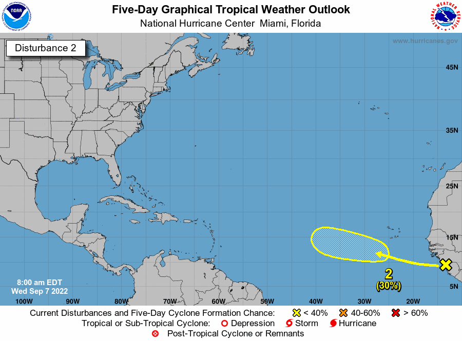
Disturbance off Africa.
Hurricane forecasters are tracking a tropical wave that’s near coast of west Africa and is expected to emerge over the Atlantic in a day or two. Environmental conditions appear generally conducive for some slow development, meteorologists said, as it moves northwest over the Atlantic. It has a 30% chance of developing into at least a tropical depression within five days.
This is the only one that may come toward us. This is the busiest time for hurricanes so more will develop.


