
Possibility of storms mid week, Not what I wanted!
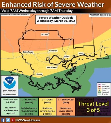
More tornadoes will be possible Wednesday in the New Orleans and Baton Rouge area, though hurricane-strength winds will be the main cause for concern. The National Weather Service has forecast an enhanced risk for severe weather Wednesday across southeast Louisiana and southern Mississippi, with storm winds possibly gusting at 74 mph. “We’re expecting pretty significant wind potential, at hurricane force or greater,” NWS meteorologist Christopher Bannan said. He said the gradient winds before and after the storm will also be damaging, potentially gusting at 50-60 mph. “That alone could knock out power, as it could damage weak limbs on trees and power lines,” Bannan said.
nola.com
There may be some flooding also as rain will accompany the winds.
Flooding is possible, with a forecasted average rainfall of 1 to 3 inches. However, isolated areas could see more than 5 inches of rain. There’s also a minimal threat for large hail. New Orleans and Baton Rouge both have a slight risk of severe weather, forecasters said. But areas north of Baton Rouge and Hammond in southeast Louisiana, and parts of southern Mississippi including McComb have an enhanced risk of severe weather. The event comes roughly a week after a tornado packing winds of 160 mph slammed into Arabi in St. Bernard Parish, destroying dozens of homes and businesses. The tornado, an EF3 on the Enhanced Fujita scale, also wreaked havoc in Terrytown, Gretna and New Orleans East, according to surveyors. To prepare for Wednesday, the NWS encourages residents to sign up for severe weather warnings and have a safe place to take shelter.
I hope this does not come as a weekly event!


